Adaptive Epistemologies and Neo-Wilds — Chapter 05
Adaptive Epistemologies and Neo-Wilds
Chapter 05
Tools
Practices, Manifests, and Speculations
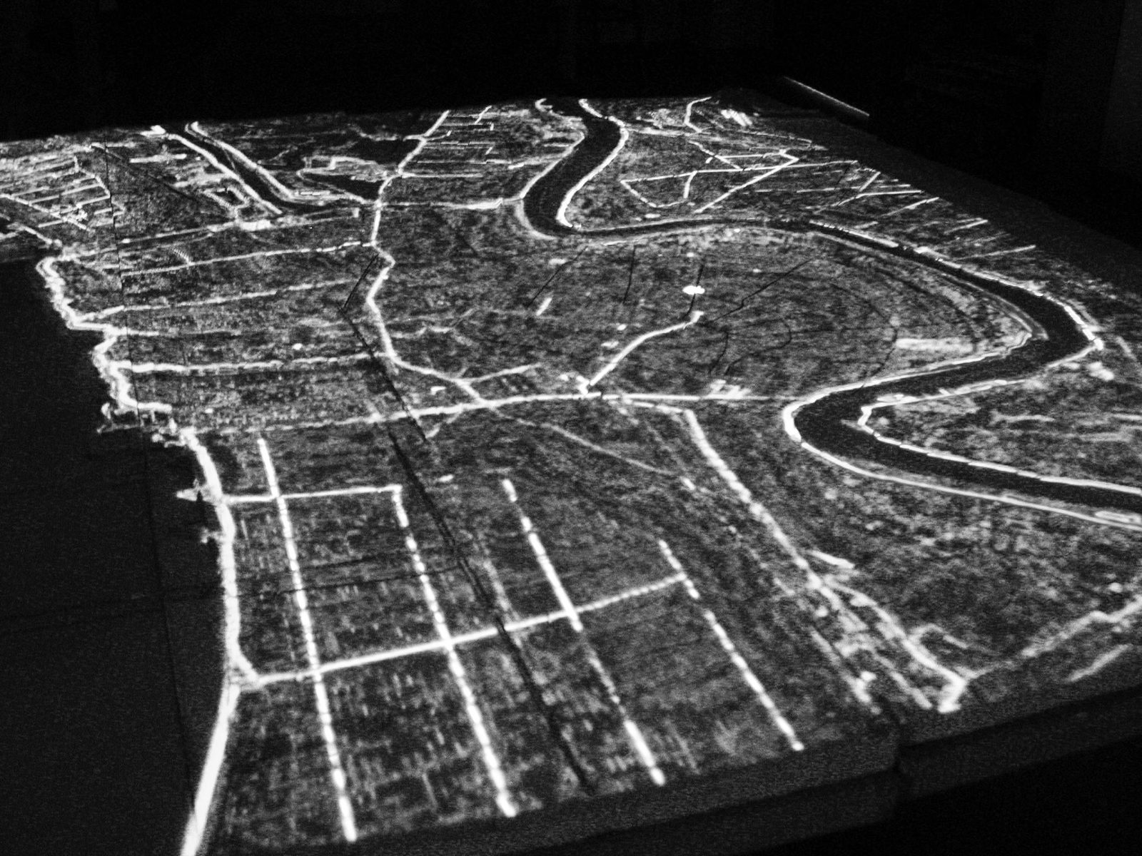
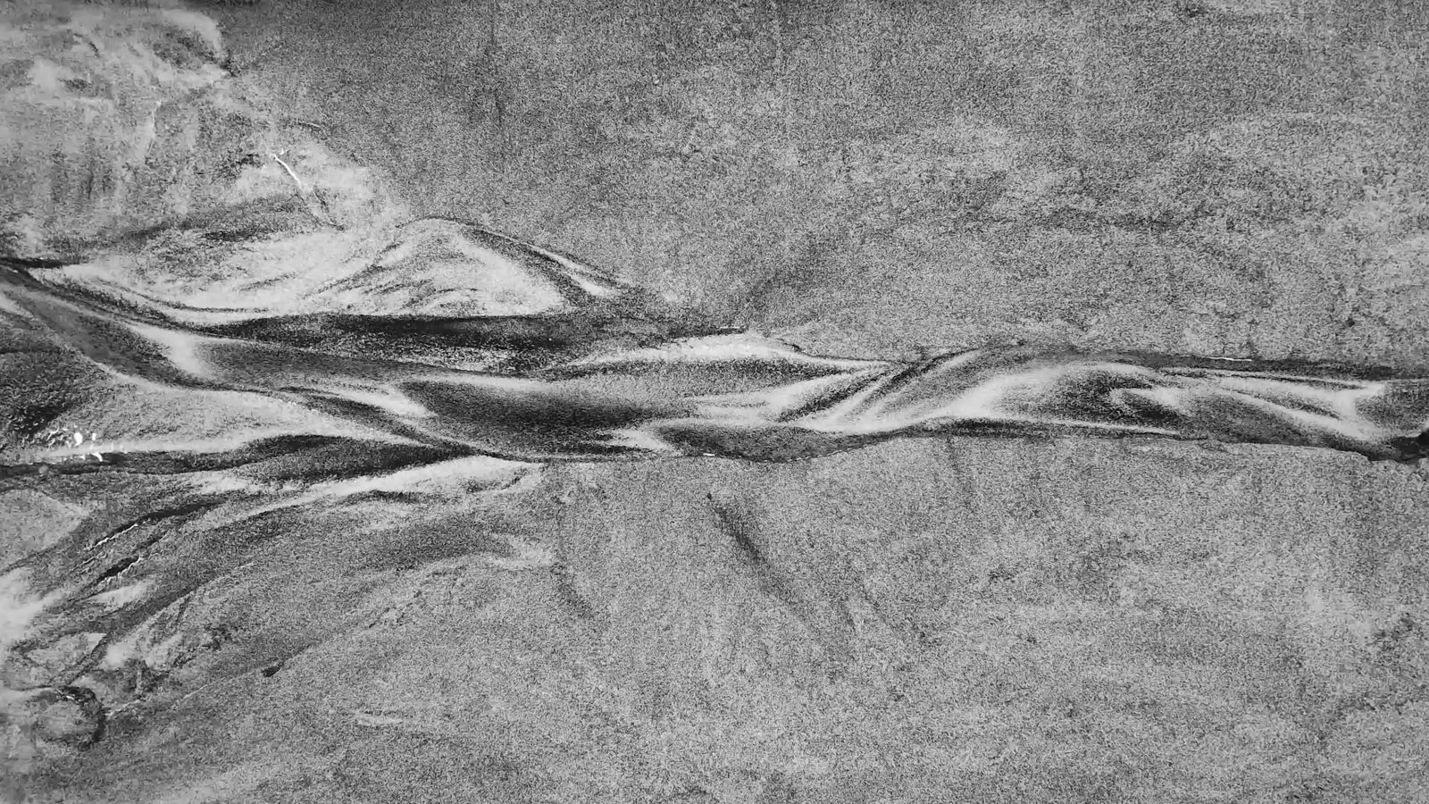
Figure 05_01 Pseudo Ecologies | Bradley Cantrell
I did not set out to build a theory. I set out to build things,
installations, models, books, studios, territorial propositions and the
theory emerged from what the building taught me. Over twenty years, each
project revised the hypothesis of the one before it. What began as a
question about representation became a question about operation, then
about codification, then about autonomy. The trajectory was not planned.
It was adaptive. The career itself is the first evidence for the
epistemology this dissertation proposes.
The Practice as Research
Instrument
Practice-based research positions creative work not as illustration
of theory but as a primary mode of inquiry, a method through which
knowledge is produced, tested, and refined. In this framework, my
accumulated body of projects constitutes an evolving research program,
each work building upon, challenging, or extending insights generated by
its predecessors. The phased structure that follows is not biographical
convenience but reflects genuine shifts in the questions being asked,
the technologies being deployed, and the scales of engagement being
pursued.
But the theoretical frameworks proposed in this dissertation did not
emerge from the projects alone. They emerged from refracting
them. Each project entered the world through instrumental contexts in
the form of grant narratives, book chapters, competition briefs,
consulting deliverables, and each context demanded a specific framing
that explained what it does, why it matters, why it should be funded or
built or published. Those framings were true but partial. They served a
purpose, and the purpose constrained what could be seen.
The method of this dissertation has been to pass the same body of
work through different narrative media and to re-read each project from
vantage points that the instrumental contexts never demanded. This
method was not arrived at theoretically. It was developed through
practice, across six Practice Research Symposia (PRS) held biannually
from 2020 to 2023, with a seventh supplementary session. At each PRS, I
presented the same body of work to my committee and peers and each time,
I retold the story slightly differently. The projects changed minimally
but the angle of inquiry changed. And from each new angle, properties
emerged that were always present but traveling invisibly within the
original framing. What I came to call refraction is the
systematic retelling of practice from vantage points its instrumental
contexts never demanded and became the dissertation’s core method as a
way of generating new conceptions from existing work by deliberately
shifting the narrative medium through which the work is examined.
The PRS structure made the refractions visible. The full account of
what the panelists named at each session, including Blythe's 'two
registers,' Kelsch's 'truth and lies,' Lootsma's 'material computers,'
and Stamm's 'virtual space of possibilities,' is developed in Chapter 3,
where these observations ground the dissertation’s methodological
argument. The PRS process revealed something specific about the tools.
Not just that the projects had been refracted, but what the refraction
recovered about the practice of tool-making itself.
Paul Kelsch, at PRS 6, pushed the methodology toward a distinction
that Ch. 03 does not fully develop. He asked whether the focus should be
on the tools or on tool-making as a form of landscape architecture
practice. Tool-making is not just preparation for tool use. It is itself
a form of knowledge production, a practice in which the designer
develops the capacity to ask questions that pre-existing tools cannot
formulate. The practice documented in this chapter is not primarily
about what the tools enabled. It is about what building them produced
epistemologically. And when Paul Kelsch pressed on the geographic
specificity of the modeling work, noting that the braided channel
formations he observed were particular to the conditions of the
Mississippi Delta rather than generalizable to rivers like the Potomac
or the Los Angeles, he was demonstrating that this tool-making knowledge
is always situated. The tools are not generic instruments but
instruments developed in and for specific material conditions. Each
re-reading reveals new properties, but also new constraints. The method
is productive because it is disciplined, not free association but
systematic inquiry from specified vantage points.
The Sedimachine was not only a prototype for coastal
sediment management. Refracted through the question of failure, it
became evidence for why sensing requires calibrated context. REAL was
not only a research lab. Refracted through the question of epistemology,
the model became a site. These refractions, conducted through the
sustained inquiry of doctoral research and tested repeatedly through the
PRS structure, are how twenty years of practice produced a theoretical
framework that no single project could have generated on its own.
The projects collected here range across registers of realization,
practices that engaged directly with institutions, sites, materials, and
implementations. They are manifests that rendered theoretical
propositions operational through scholarship, prototypes, and working
demonstrations and speculations that tested ideas through projective
scenarios and disciplined imagination. Across these registers, the work
has consistently interrogated a central question, how might landscape
architecture move from designing static forms to choreographing
responsive processes? The answer, it turns out, required learning to see
differently, then to touch, then to code, and finally to let go. Full
project documentation, including technical specifications, collaborator
credits, and exhibition histories, is gathered in Appendix A. This
chapter traces the epistemological arc across the practice, reading each
project for what it contributed to the frameworks the dissertation
proposes.
The mid-2000s presented landscape architecture with a
representational crisis. Digital tools imported from architecture
struggled to capture the indeterminacy fundamental to landscape
materials. The vector line implied precision where the landscape
demanded flux. Before I could intervene in dynamic systems, I had to
learn to see them. The projects of this phase interrogated the mechanics
of representation itself.
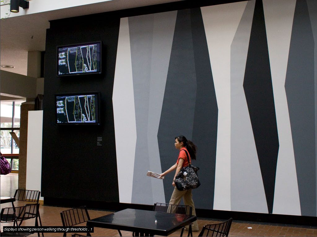
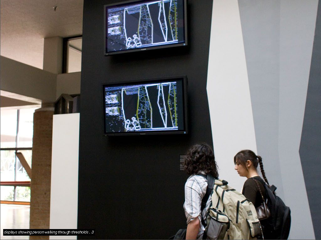
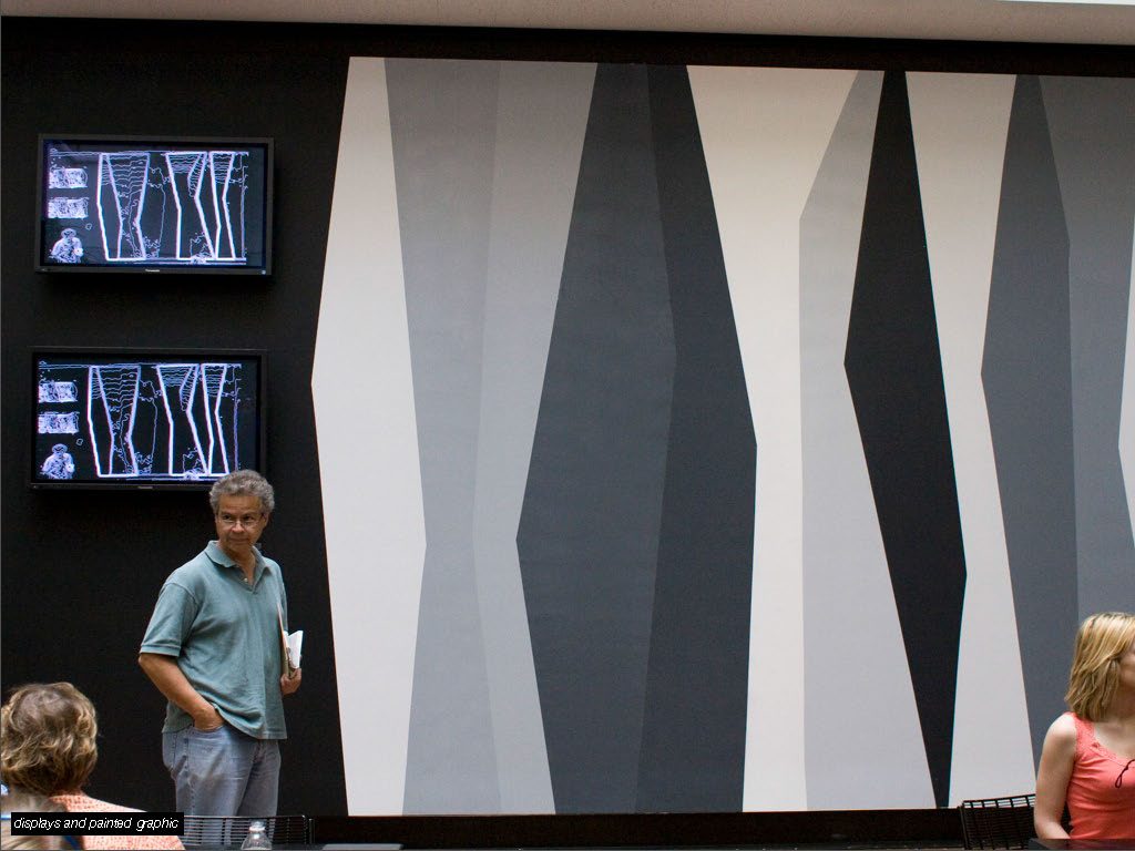
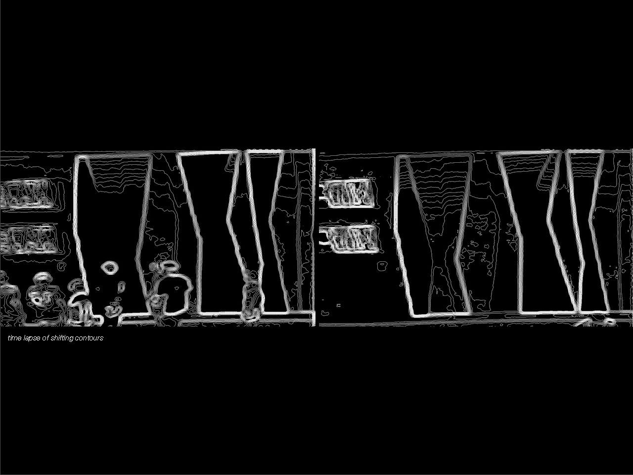
Thresholds (2006), an interactive installation at Louisiana
State University developed with Wes Michaels, was the first experiment.
A high-contrast mural served as a visual datum, a camera performed
continuous blob detection, custom Processing software converted contrast
gradients into isolines displayed in real-time. As pedestrians moved
through the atrium, they disrupted the contrast field, generating
ephemeral topographies. Occupants became unwitting participants in
landscape generation, their bodies registering as topographic events. At
the time, the project was framed as a technology demonstration, an
exploration of real-time sensing in architectural space. Refracted
through this dissertation, it reveals something else, the first evidence
that representation in landscape architecture is not transcription but
interpretation. The contour line, the profession’s most fundamental
notation, was shown to be an active construction of gradient and
threshold rather than a neutral recording of existing terrain. Pietrusko
names this principle directly. Data does not simply inform knowledge. It
produces the categories through which the world becomes legible
(Pietrusko 2020). Thresholds enacted that argument before I had
the language for it. The defamiliarization, making the familiar strange
so that its assumptions become visible, would prove to be the deeper
contribution.
A parallel experiment, Surface Tension (2006–07), pushed the
representational question into the material register. Cast landscape
surfaces embedded with electronics, LEDs, and sensors responded to
physical interaction, a model that was simultaneously representation and
instrument. Touching the surface triggered responses, making the terrain
behave as a primitive responsive landscape at miniature scale. At the
time, the project was treated as an exercise in embedded computation, a
curiosity. Refracted, it established a principle that REAL and the UVA
lab would later realize at research scale. That physical models need not
merely record or depict but can actively produce knowledge through
engagement. The model as operational instrument, not passive object,
begins here.
Figure 05_07Thresholds Installation, Louisiana State University College of Art and Design | Bradley CantrellFigure 05_08Thresholds Installation, Louisiana State University College of Art and Design | Bradley Cantrell
The ACADIA paper, Ambient Space (2007), articulated the
theoretical distinction that would anchor everything that came after.
Computation in landscape is not a tool for depicting spaces but a medium
for constituting them. Processing-based software sketches translated
real-time sensor input into spatial projections, environments that
responded to presence and movement rather than recording fixed
conditions. The shift from digital drawing to digital landscape, from
representation to medium, was named here before it was built
anywhere.
Abstraction Language (ACADIA 2009) extended this into
ecological territory, proposing a systematic vocabulary for moving
between quantitative data and spatial design operations. The paper
argued that the gap between ecological datasets and design decisions was
a representational problem, not a technical one, and that the operations
bridging them, filtering, layering, thresholding, interpolating, were
themselves epistemological commitments. Tools are not neutral. They
encode claims about what matters and what can be seen. This argument,
that the tool is a manifest, would become foundational to the
dissertation’s understanding of computation in landscape design.
Figure 05_09Thresholds Installation, Louisiana State University College of Art and Design | Bradley CantrellFigure 05_10Thresholds Realtime Isoline Visualization | Bradley Cantrell
Over/Under (2009), a competition entry for Lausanne Jardins
developed with Allen Sayegh, Edith Ackermann, and Marcella Del Signore,
staged this insight materially. A single specimen citrus tree was
sustained by visible hydroponic infrastructure above a subway station,
its growth following its own seasonal rhythm regardless of the
technological apparatus supporting it. The plant was maintained by
systems its audience never saw, responding to biological logic rather
than design specification. In embryonic form, this was the relationship
between designed infrastructure and biological autonomy that the later
chapters develop as the cultivant.
Figure 05_11Surface Tension Model, Louisiana State University | Bradley CantrellFigure 05_12Surface Tension Model, Louisiana State University | Bradley Cantrell
These experiments in seeing culminated in two publications.
Digital Drawing for Landscape Architecture (2010), co-authored
with Wes Michaels and recipient of the 2012 ASLA Award of Excellence in
Communication, gave the discipline a methodology for digital
representation calibrated to its specific concerns. The core
contribution was the concept of the digital composite, a recognition
that landscape representation requires layering heterogeneous
information that no single software engine can generate. The hybrid
workflow synthesized the precision of vector drawing with the ambiguity
of raster imagery, producing representations capable of holding the
indeterminacy fundamental to landscape materials. Published as a
professional textbook, a how-to guide for practitioners transitioning to
digital workflows, the book’s refracted contribution is epistemological,
the way a landscape architect draws a site determines how they
understand it. Vector lines imply hard edges, landscape materials are
defined by flux. By equipping the discipline to represent atmospheric
depth, we equipped it to think about higher levels of complexity.
Figure 05_13Surface Tension Model, Louisiana State University | Bradley CantrellFigure 05_14Surface Tension Model, Louisiana State University | Bradley Cantrell
Modeling the Environment (2012), co-authored with Natalie
Yates, introduced the critical dimension of time. A building is finished
when construction ends, a landscape is just beginning. The book
demonstrated procedural and parametric modeling approaches, terrain that
could erode, forests that could grow across decades according to
ecological logic and argued for integrating data directly into design
models. Again, the instrumental framing was pedagogical, software
instruction for students. Refracted, the book enacted the shift from
representation to analysis, the digital model transformed from a picture
of the site into a database of the site. When the model contains actual
geospatial information, it becomes an instrument for investigating
dynamics rather than depicting appearance.
The third contribution of this phase was institutional rather than
representational. The Coastal Sustainability Studio and its technical
research arm, the TiKI Lab (Technologies, Information, Knowledge,
Interaction), established at LSU from 2010 to 2013 with Jeff Carney,
Lynne Carter, and a shifting community of researchers, demonstrated that
the trans-disciplinary studio culture landscape architecture brings to
territorial problems could function as a primary mode of knowledge
production. The CSS mobilized landscape architects, environmental
scientists, urban planners, and community advocates to develop
resilience strategies for Louisiana’s coastal crisis. The TiKI Lab
produced animated visualizations, spatial narratives, and interactive
GIS platforms that translated complex geospatial data into formats
accessible to affected communities and policymakers, feeding directly
into Louisiana’s coastal protection and restoration planning. Framed
institutionally as applied research and community service, the CSS/TiKI
Lab’s refracted contribution was a demonstration of visualization as
argument at territorial scale. The choice of what to show, how to show
it, and for whom, was never neutral. The tools were manifests, encoding
particular claims about whose futures mattered and what kinds of
knowledge deserved to be made public. A sensor deployment in a wetland
serves different purposes for engineers, ecologists, and designers. The
same apparatus coordinates action across disciplines precisely because
it allows each to project its own questions onto shared data, what Star
and Griesemer (1989) call a boundary object. That lesson, that the same
instrument can hold different meanings for different communities while
still enabling collaboration, carried into every sensing infrastructure
and data visualization that followed.
By 2012, I had a better grasp on how to see dynamic systems, but
seeing was not enough. The installations showed me feedback loops and
the books gave the discipline a visual language for temporal processes.
What I had not yet done was touch the material, put my hands in the
sediment, build the apparatus, close the loop between sensing and
physical intervention. That required a different kind of laboratory.
Learning to Touch (2012–2016)
If Phase I asked how to represent dynamic systems, Phase II asked how
to operate within them. The Mississippi River Delta, where the boundary
between “natural” process and engineered infrastructure had long since
collapsed, became the laboratory. Sediment deposition builds land while
subsidence and sea-level rise consume it. Levee systems constrain flows
that once nourished wetlands. Oil infrastructure threads through
ecosystems it simultaneously exploits and endangers. The Delta demanded
more than better pictures, it demanded better instruments.
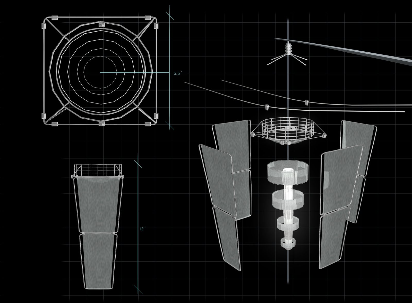
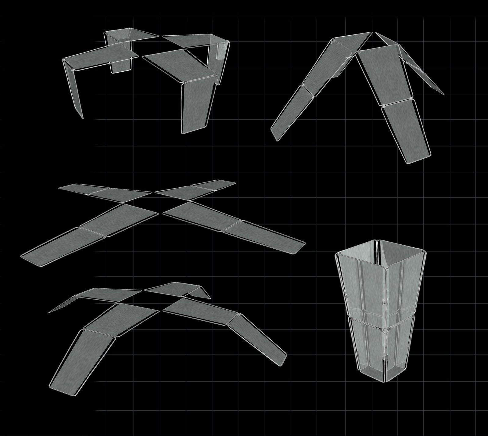
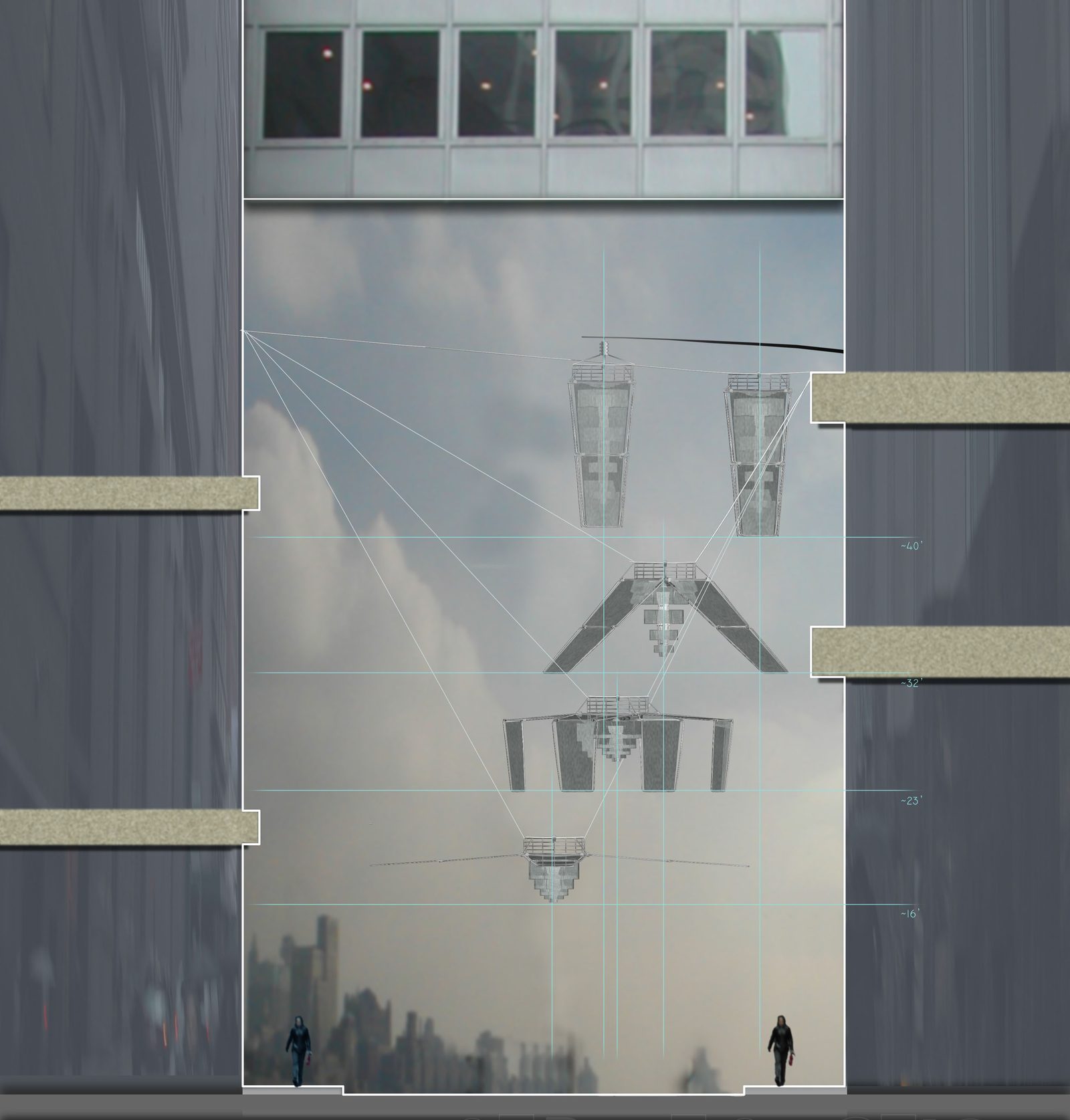
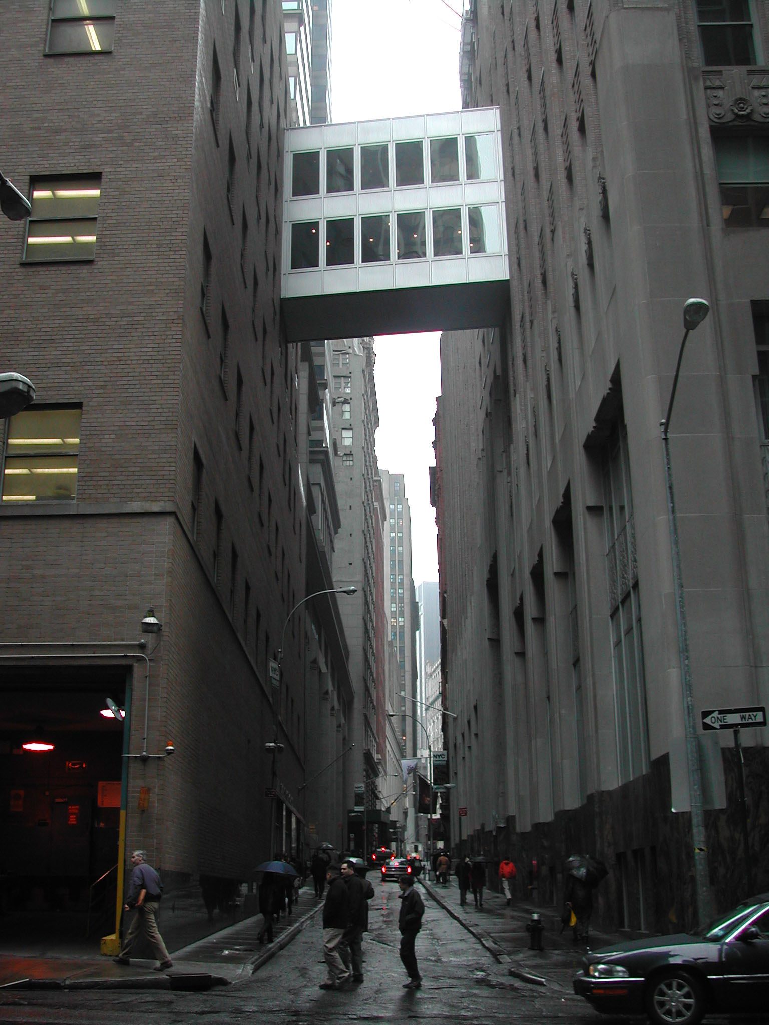
Figure 05_16Pine Street Responsive Lighting Infrastructure, New York, NY | Bradley CantrellFigure 05_17Pine Street Responsive Lighting Infrastructure, New York, NY | Bradley Cantrell
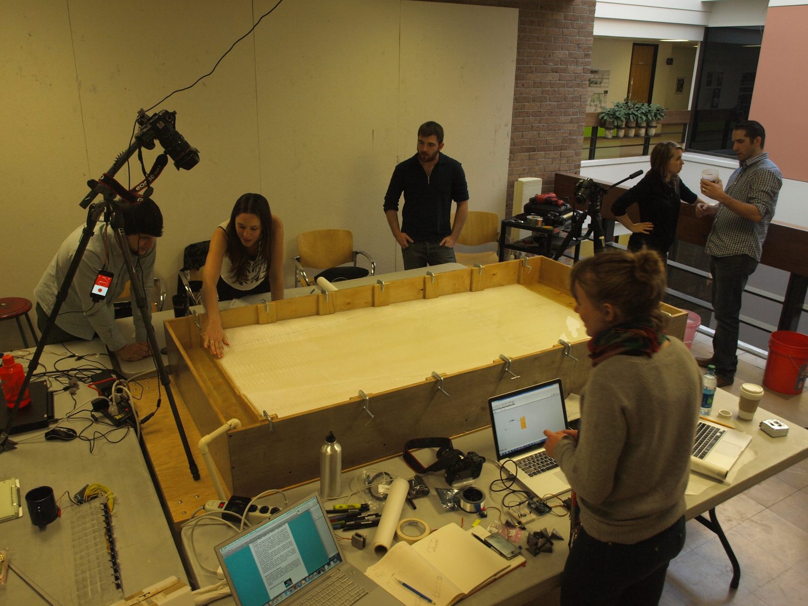
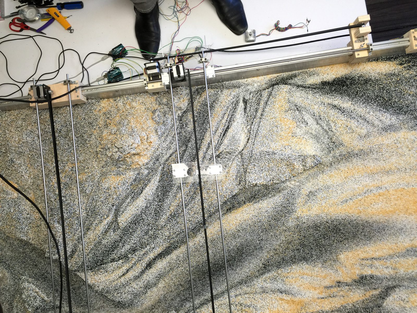
The Sedimachine (2012), developed with Frank Melendez at
LSU, was the first apparatus. A plexiglass surface at an incline, water
delivered via a perforated copper tube, sand patterning according to
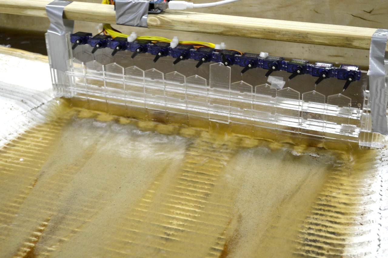
which perforations were open. Phase two added a robotic spillway, twelve
operable gates controlled through Arduino, transforming the apparatus
from passive observation into active choreography. As a research
prototype, the Sedimachine was framed as proof-of-concept for
controlled sediment deposition, a step toward coastal land-building.
Refracted, it established a foundational distinction that runs through
the entire dissertation, between designing forms and designing the
operations that generate forms. The perforated tube and robotic spillway
were instruments for choreographing process rather than specifying
outcome.
Figure 05_18Pine Street Responsive Lighting Infrastructure, New York, NY | Bradley CantrellFigure 05_19Pine Street Responsive Lighting Infrastructure, New York, NY | Bradley Cantrell
The Sedimachine also produced a productive failure. A
Microsoft Kinect depth sensor, deployed to document surface morphology,
proved unable to capture the thin depositional layer. Rather than
abandoning digital documentation, this limitation drove the search for
modeling systems producing more substantial morphological change and for
complementary sensing approaches operating at different scales and
resolutions. Refracted through the question of methodology, the Kinect
failure became evidence for a principle, that sensing requires
calibrated context. Without appropriate resolution, data is noise.
Failure became a research driver, a principle I would return to
repeatedly.
The Kinect could not resolve the thin depositional layer, and that
technical limitation revealed that sensing resolution defines what the
territory can make legible. The failure redirected the lab toward
ultrasonic and image-analysis modalities, not as better instruments in
the abstract, but as instruments calibrated to the scale at which the
phenomenon was operating. The question of which scales of environmental
experience get instrumented, and which are left invisible, carries
justice implications that follow directly from this technical
finding.
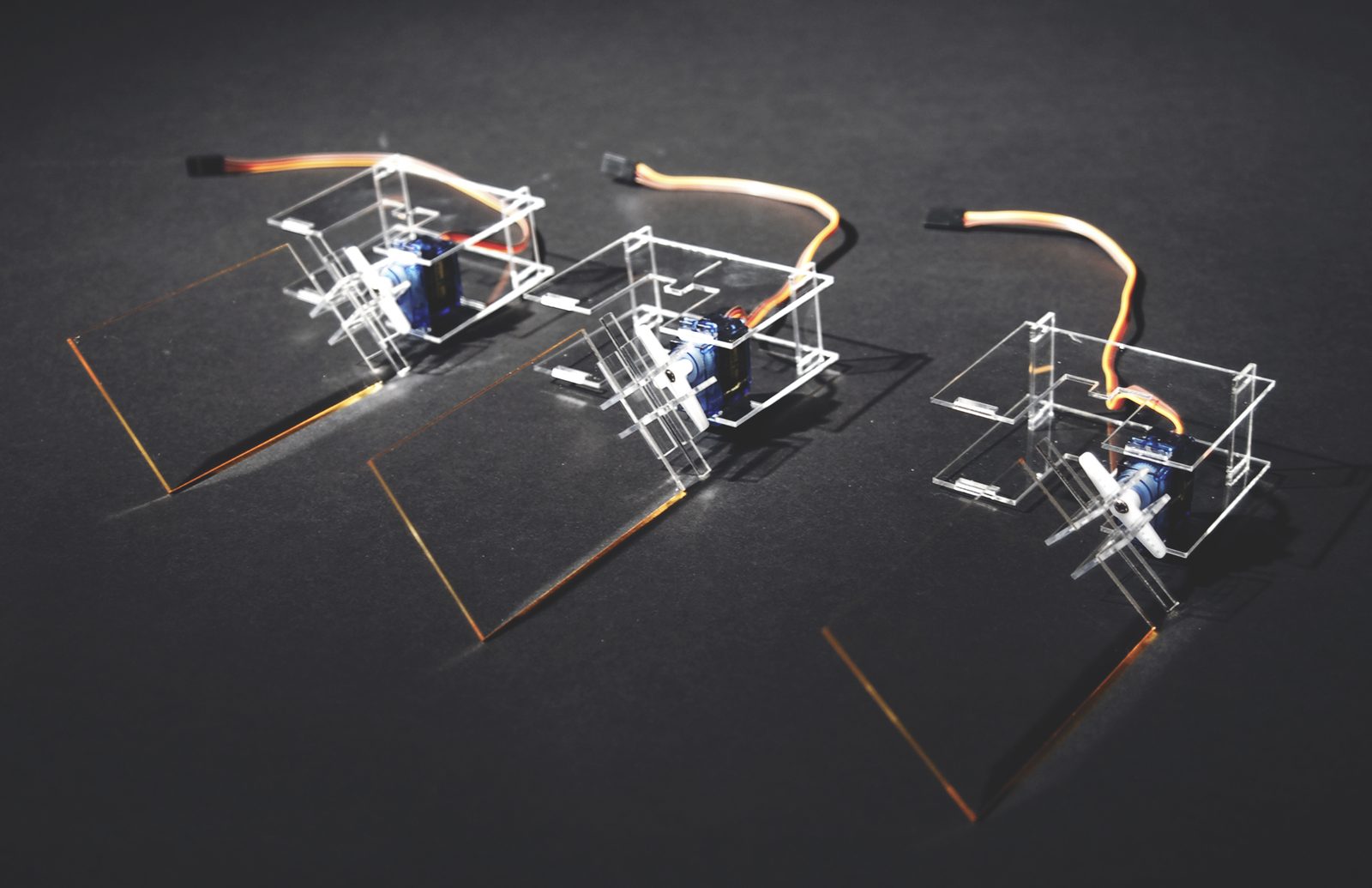
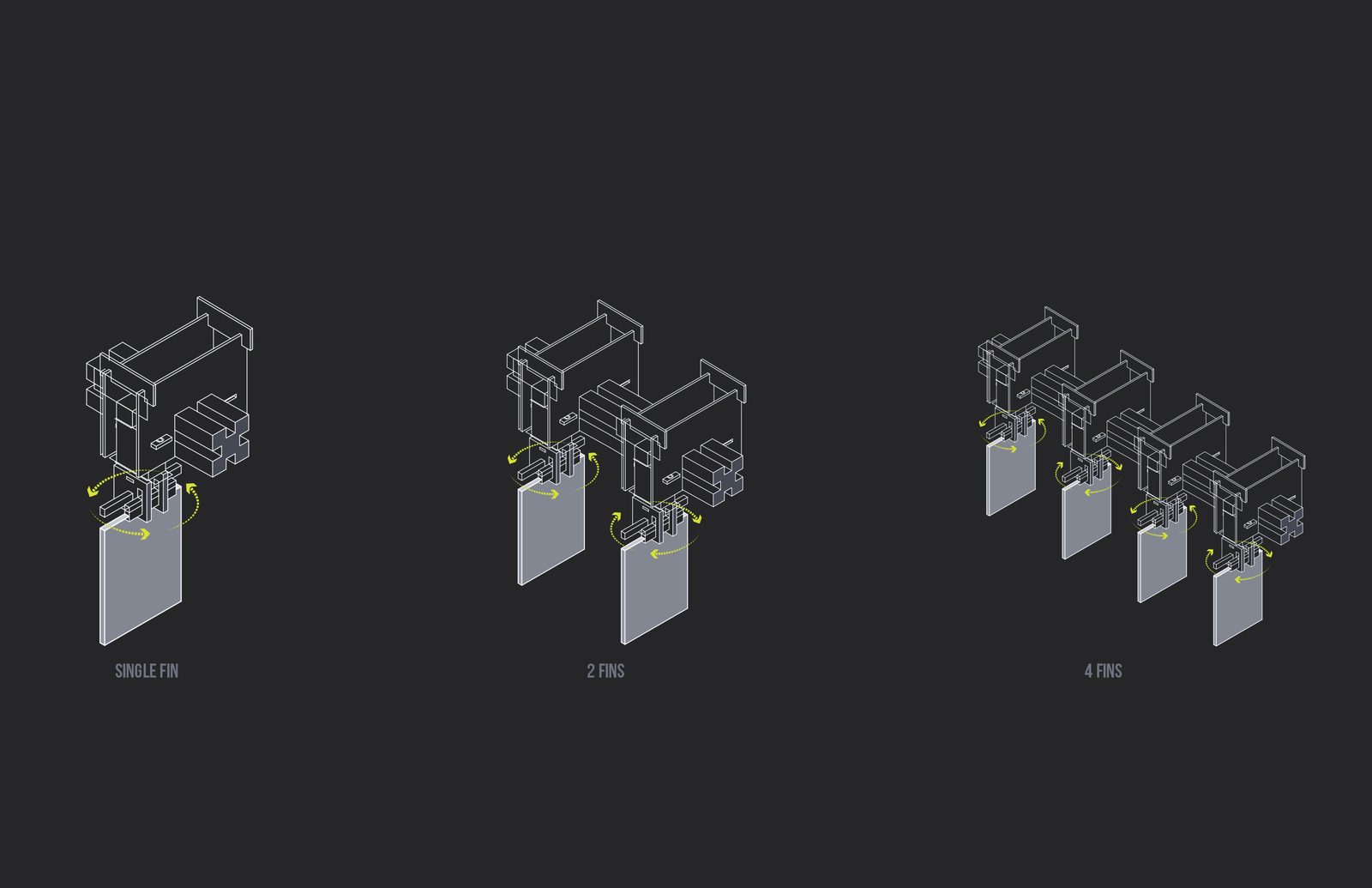
Figure 05_30FIN, Tyler Mohr and Andrew Boyd | Responsive Environments and Artifacts LabFigure 05_31FIN, Tyler Mohr and Andrew Boyd | Responsive Environments and Artifacts Lab
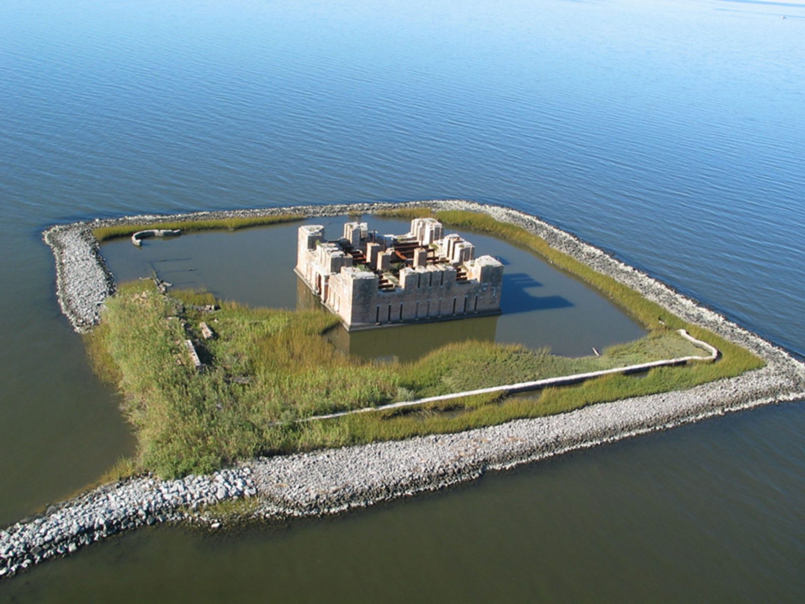
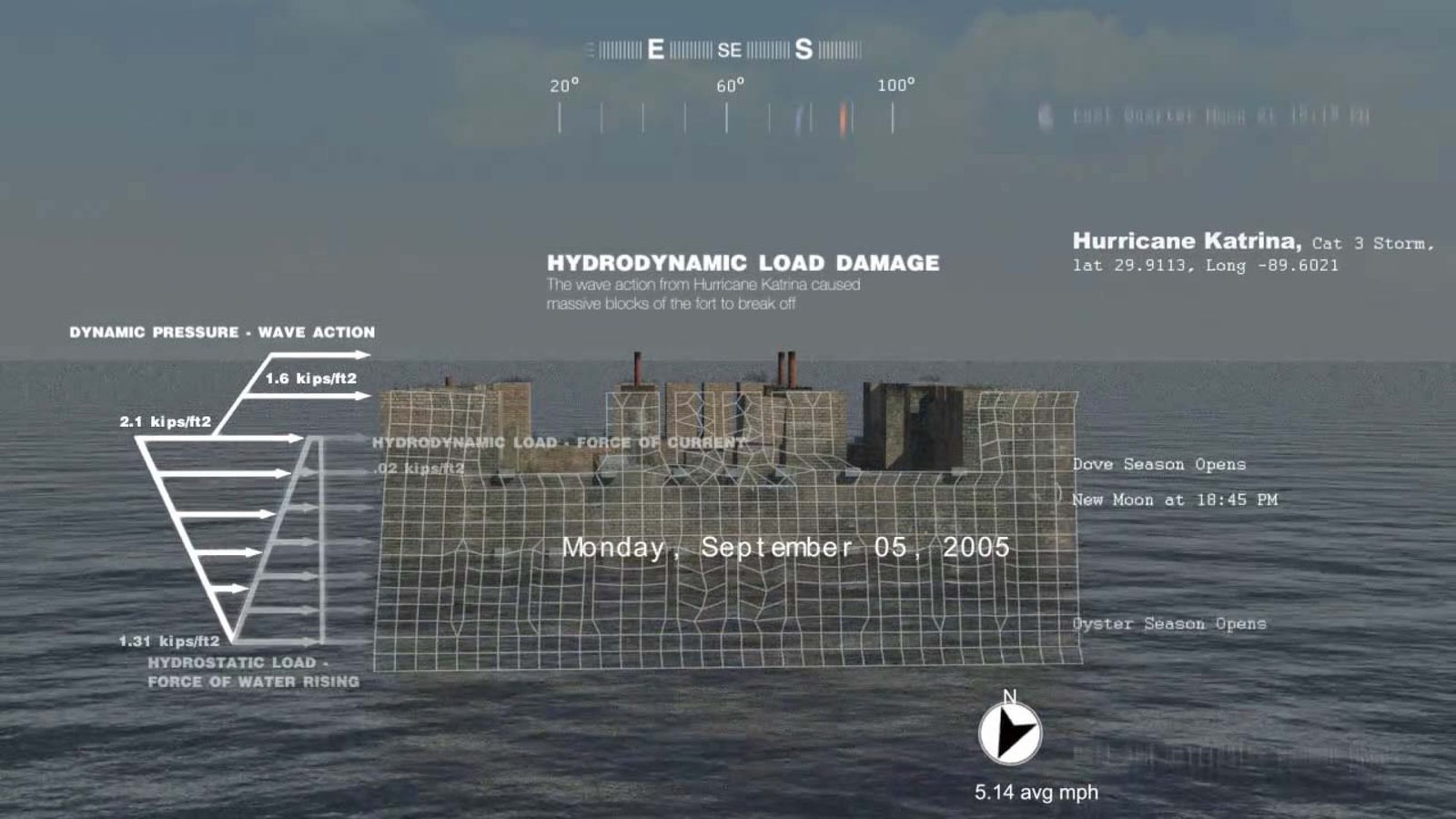
Fort Proctor: A Conditional Preservation (2013), co-authored
with Emery McClure and presented at ARCC, brought this logic into direct
confrontation with cultural heritage. Fort Proctor, a Civil War-era
fortification in Plaquemines Parish, now stands entirely surrounded by
water, the land that once connected it to the mainland long since eroded
and subsided. Traditional preservation assumes a stable ground. The
building endures because the land endures. Fort Proctor makes
that assumption impossible. The design research proposed what the paper
terms “conditional preservation,” strategies calibrated to the fort’s
ongoing submergence rather than to a fixed historical moment. Not
restoration to an origin, but designed engagement with the process of
loss itself. Refracted, Fort Proctor named something the
Sedimachine had begun to show but couldn’t fully articulate.
The ground is not a datum. It is a process. Every design intervention,
every act of preservation or management or sensing, engages a surface
already in motion. This reframing of ground as dynamic, not stable, runs
beneath all the composite modeling work that followed.
Figure 05_32Robotic Sediment Gates, Dredgefest 2014, Louisiana State University | Bradley Cantrell, Justine Holzman, Prentiss Darden, David MerlinFigure 05_33Robotic Sediment Gates Choreography Diagram, Dredgefest 2014, Louisiana State University | Bradley Cantrell, Justine Holzman
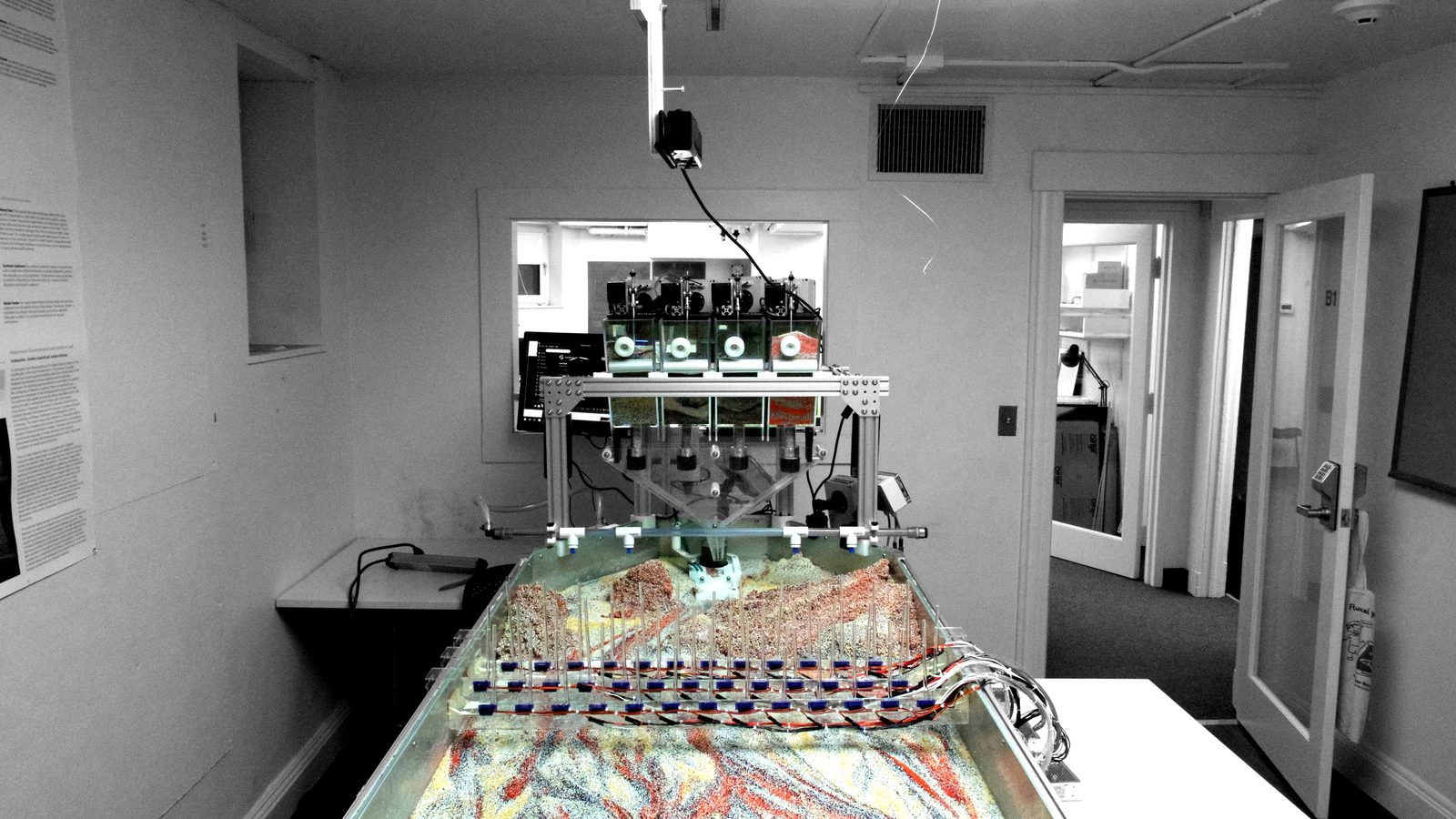
The search led to the Responsive Environments and Artifacts Lab
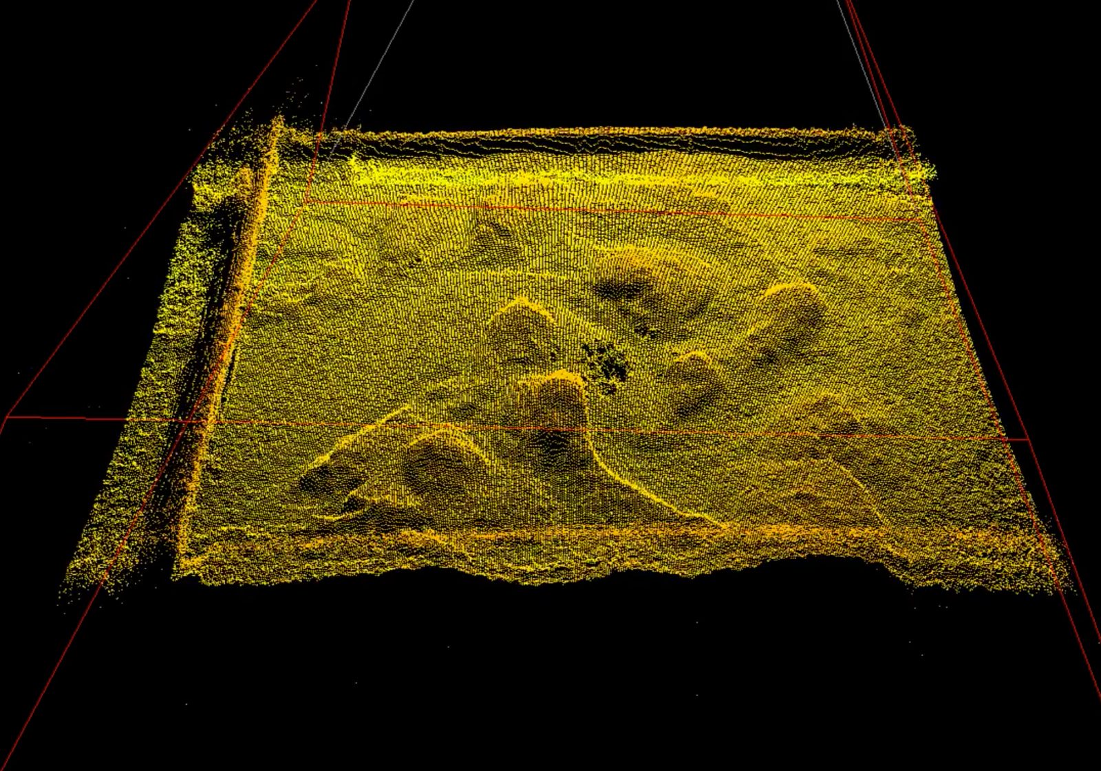
(REAL) (2014–2017), co-directed with Allen Sayegh at the Harvard
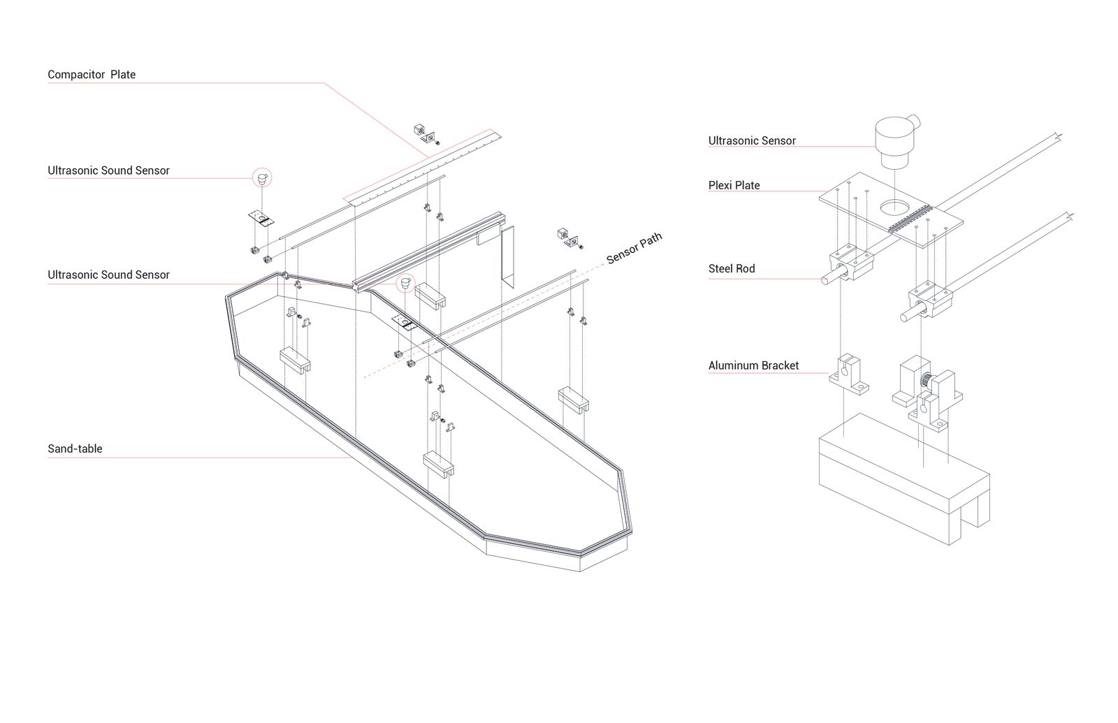
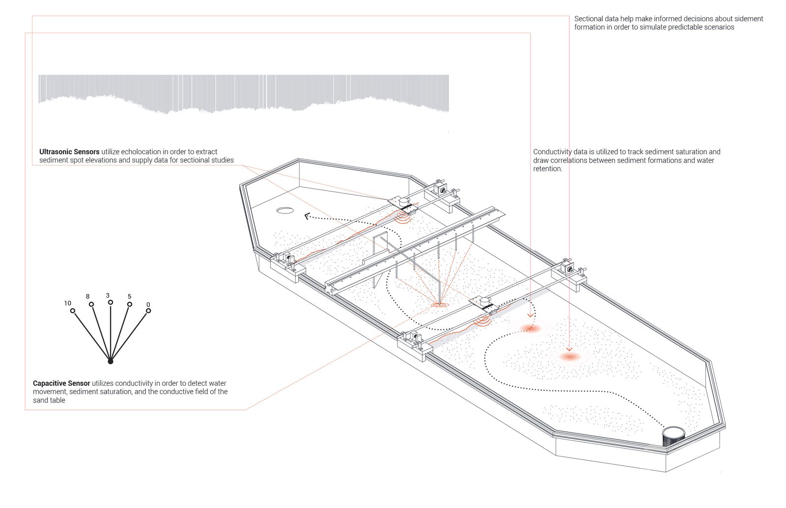
Graduate School of Design. REAL’s primary instrument was an EmRiver
geomorphology table augmented with multi-modal sensing, overhead Kinect
for continuous point clouds, ultrasonic range-finding for precise spot
elevations, image analysis for tracking sediment behavior, dye
visualization for flow patterns. The overlay of sensing modalities
produced data at multiple resolutions and temporalities, a continuously
updated digital representation of a physical model’s own dynamic
behavior.
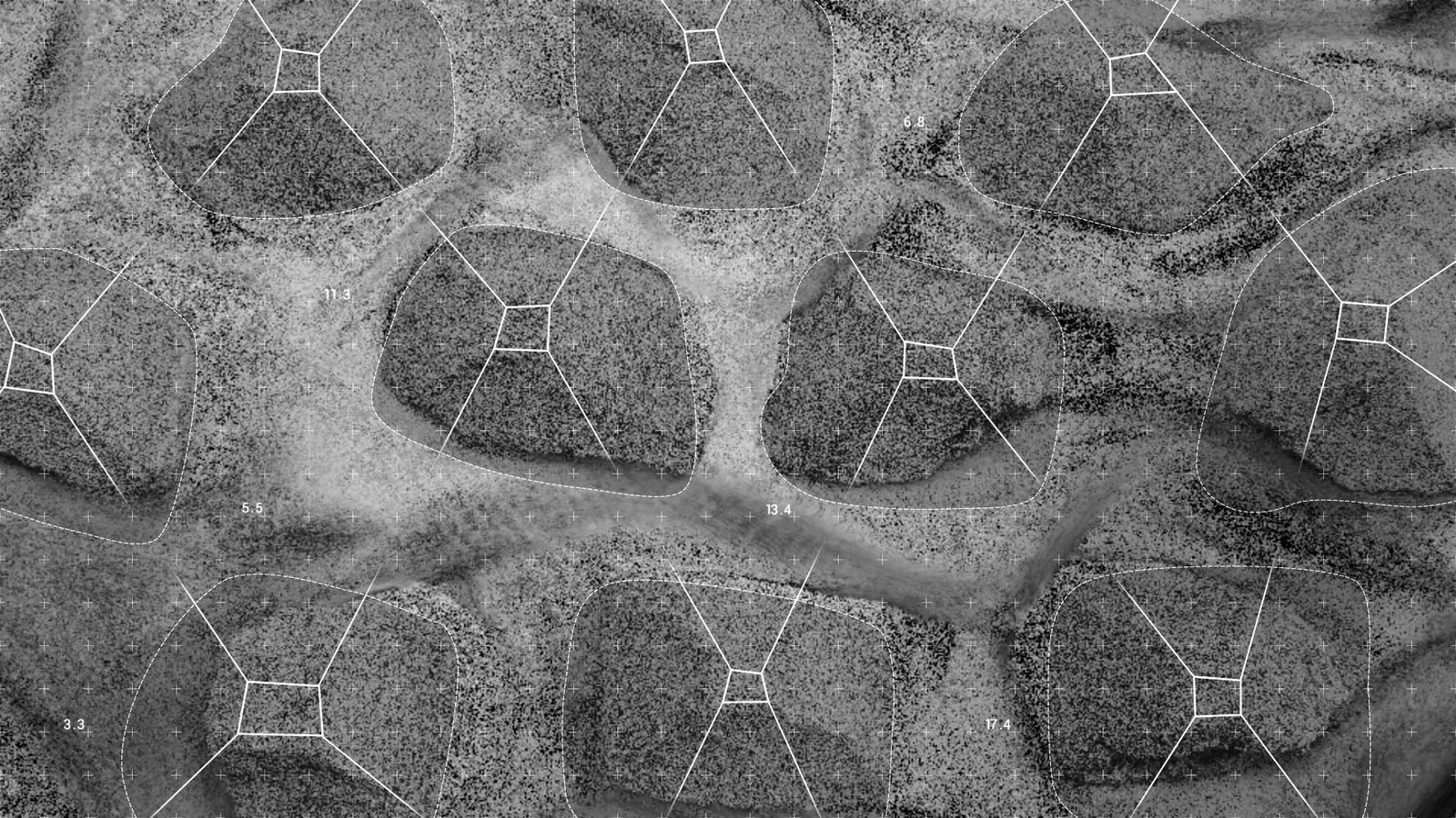
What REAL established was composite modeling as a design methodology.
The history of physical hydraulic modeling provides essential context.
As Hubert Chanson has documented, reduced-scale models have been used
since antiquity to study flow phenomena, but the practice reached
institutional maturity through massive installations like the U.S. Army
Corps of Engineers’ Mississippi Basin Model at Vicksburg. These models
enabled engineers to observe complex fluid dynamics that resisted
mathematical formalization in turbulence, sediment transport, and
channel migration through direct material engagement. Yet traditional
hydraulic models remained analog instruments, observed by human eyes and
interpreted through engineering judgment. REAL asked what might become
possible when physical models were instrumented with digital sensing and
coupled to computational analysis.
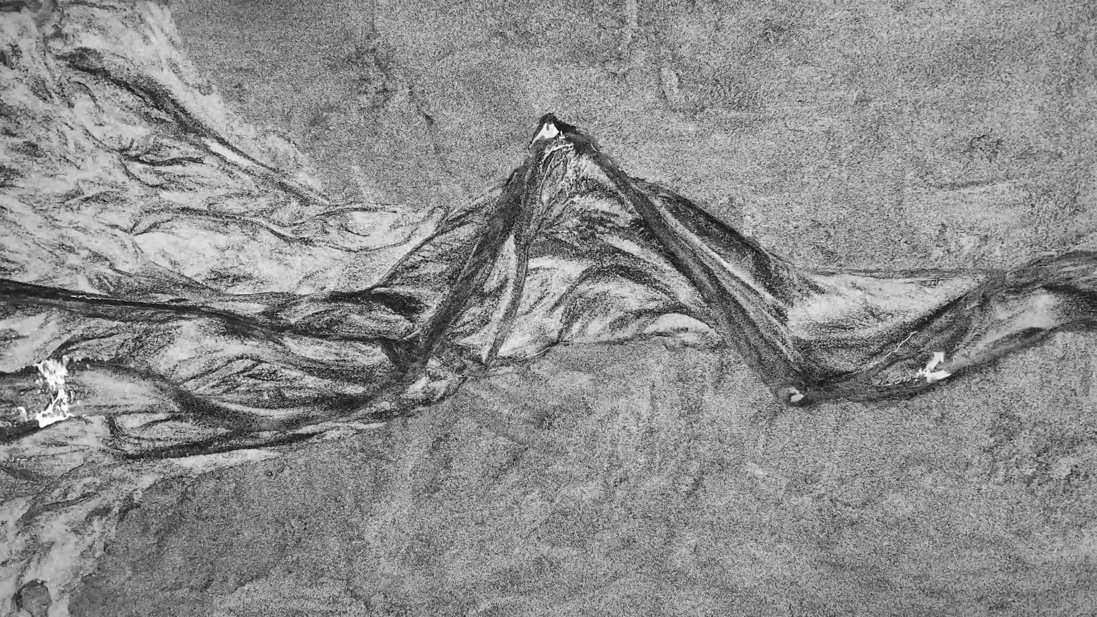
The answer was composite modeling, physical models that excel at
reproducing emergent behaviors, sediment sorting, channel braiding, and
delta lobe switching coupled with digital systems that excel at pattern
recognition, analysis across scales, and control logic. Justine Holzman,
who co-developed the REAL methodology and has written the most precise
account of its epistemological stakes, describes this as “hydraulic
modeling as craft”. The effectiveness of these models depends on the
skill of the modeler “to in certain situations, know if it looks right,
and to understand, intuitively, how to alter or shift the model to guide
results” (Holzman 2016). This is not engineering judgment in the
conventional sense but a design intelligence developed through sustained
material engagement, the modeler reading the sediment the way a
craftsperson reads the grain of wood. Chris Paola and colleagues have
argued for the “unreasonable effectiveness” of such experimental
stratigraphic work, REAL extended this insight from scientific
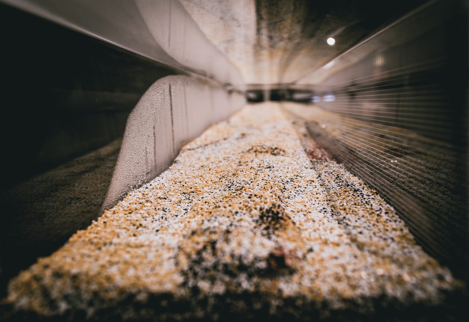
investigation to design methodology. The geomorphology table operated
with synthetic sediment particles of varying sizes and densities,
self-organizing based on water velocities to produce stratigraphic
patterns analogous to natural fluvial deposits. Programmable pumps
controlled stream and groundwater flow through repeatable hydrographs.
The overlay of sensing modalities, overhead Kinect sensor for continuous
point clouds, ultrasonic sensors on motorized rails for precise spot
elevations, image analysis for tracking morphological change, dye
visualization for flow patterns, produced data at multiple resolutions
and temporalities, from continuous low-resolution topography to precise
spot measurements, from instantaneous flow visualization to
long-duration morphological tracking. None of these outputs were neutral
representations. Every choice of scale, color ramp, and viewpoint shaped
what the viewer would focus on (Drucker 2014). The heatmap of sediment
accumulation is not a transparent window onto process. It is an argument
about what matters, and the designer who builds the visualization is
making that argument whether or not they recognize it.
Figure 05_36Responsive Environments and Artifacts Lab Geomorphology Model | Bradley Cantrell, Steve GoughFigure 05_37Responsive Environments and Artifacts Lab Geomorphology Model | Bradley Cantrell, Steve Gough + Towards Sentience Thesis Prototype | Leif EstradaFigure 05_38Responsive Environments and Artifacts Lab Geomorphology Model and Banner Ultrasonic Sensor Assembly | Bradley Cantrell
Institutionally, REAL was framed as a research lab, infrastructure
for funded investigations into responsive technologies. Refracted
through this dissertation, its deepest contribution is the concept of
the model-as-site. Traditional hydraulic modeling seeks similitude,
mathematical relationships (Froude scaling, Reynolds numbers)
establishing proportional correspondence between model and prototype.
REAL deliberately departed from this convention. The geomorphology table
was conceived as its own environment, with its own elements of novelty
and surprise, rather than a scaled replica of any particular landscape.
The presumed scale was illustrative and diagrammatic rather than
establishing linear relationships with real-world conditions. This is
what Bart Lootsma recognized when he described the models as “material
computers” and devices in which computation is embedded in the material
behavior itself, not imposed from outside.
This reframing, from prediction to discovery, from surrogate to site,
is one of the dissertation’s central epistemological moves. Rather than
using models to predict outcomes in specific locations, designers could
use them to discover principles of interaction between flow, sediment,
and intervention. The model became a generative space, a dialogue
between experimental environment and the broader systems it serves to
inform, where design intentions could be tested against material
dynamics without claiming predictive authority. Bernard Patten and
Eugene Odum’s work on the cybernetic nature of ecosystems provided
theoretical grounding, while Antoine Picon’s historical scholarship on
French hydraulic engineering illuminated how technical knowledge
develops through iterative engagement with territorial systems.
Figure 05_39Branding Islands Making Nations Representation Test | Bradley CantrellFigure 05_40Branding Islands Making Nations Representation Test | Bradley CantrellFigure 05_41Responsive Environments and Artifacts Lab Geomorphology Realtime Point Cloud | Bradley Cantrell
The feedback between sensing and physical model enabled development
of responsive prototypes in the form of robotic sediment gates,
repositionable sieves, and flow disruptors, expressing a new design
vocabulary of “choreography and resistance.” Three modes of engagement
emerged, direct interaction through physical manipulation, responsivity
through sensing-driven reaction, and autonomy through systems that learn
behaviors through feedback. Student work pushed these frameworks in
directions the lab itself could not have anticipated. Leif Estrada’s MLA
thesis, “Towards Sentience,” explored the deconstruction and
reconstitution of the Los Angeles River through individually controlled
insertions that redirect sediment from demolished concrete channel,
working with cyclical hydrology to re-pattern the river bed, the new
channel emerging through interactions that guide outcomes within
controlled ranges. Andrew Boyd and Tyler Mohr’s “FIN” developed a
systematic taxonomy of flow-modification devices, producing topographic
plans that speak to movement and probabilities of change,
representations expressing landscape as gradient between stasis and flux
rather than fixed form. Ricardo Jnani Gonzalez’s “Attuning Sediment
Transfer” investigated how actuated elements could choreograph
deposition patterns. The lab was generating a new kind of design
intelligence, one that could not be reduced to any single researcher’s
intentions.
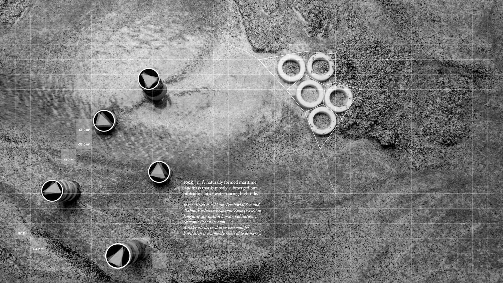
But if REAL taught me how material systems behave, Branding
Islands Making Nations (2016), developed with the Vertical
Geopolitics Lab for the Venice Architecture Biennale, taught me that
material processes are never separable from political ones. The project
examined how constructed land acquires political existence through
representational practices as much as through material deposition. An
artificial island becomes sovereign territory not merely when sand is
dredged but when it appears on official maps, receives a name, and
circulates through media imagery. A satirical competition invited
marketing professionals to develop branding packages for contested
landmasses in the South China Sea, exposing the mechanisms by which
representation manufactures political reality. As a Biennale exhibition,
this was cultural critique and provocation. Refracted, it forced a
reckoning with the designer’s complicity that would reshape the ethical
framework of everything after it, the capacity to choreograph
land-making processes is also the capacity to enable territorial
expansion and displacement. The justice dimensions of the Chesapeake Bay
work and the ethical complexity of the NEOM consultation both trace back
to this confrontation.
Responsive Landscapes (2016), co-authored with Justine
Holzman, consolidated Phase II’s insights into transmissible theory. The
book provided the discipline with a precise taxonomy of responsive modes
in six categories (elucidate, compress, displace, connect, ambient,
modify) describing how technology might mediate between environmental
process and human experience. The taxonomy moved conversation beyond
vague notions of “smart” landscapes to specific design strategies.
Published as a professional reference, the book’s refracted contribution
was to reframe technology in landscape from a question of efficiency to
a question of phenomenology, changing not just how systems perform but
how humans perceive and interact with environmental processes. The
gradient from elucidate through modify traced increasing levels of
technological intervention, and the book introduced landscape as
cybernetic system with environments characterized by feedback loops
between sensing, processing, and actuation, updating mid-century
cybernetic theory for contemporary ecological contexts.
Figure 05_42Experiments Wall Exhibition, Harvard Graduate School of Design | Bradley Cantrell, Jeremy Hartley + Photos by Keith ScottFigure 05_43Experiments Wall Exhibition, Harvard Graduate School of Design | Bradley Cantrell, Jeremy Hartley + Photos by Keith Scott
By the end of Phase II, I could touch the material, close the
feedback loop, and name what I was doing. But I was still using other
people’s tools. The question became, what happens when you open the
black box and write your own?
Learning to Code (2016–2020)
The move from LSU to Harvard and subsequently to the University of
Virginia marked an institutional scaling of the computational agenda.
Architecture’s parametric turn had produced formally complex buildings
but landscape’s computational turn would need to produce something
different, in particular tools for managing ecological complexity,
indeterminacy, and temporal depth. The projects of this phase focused on
codification in multiple senses including the literal writing of code,
the establishment of protocols and taxonomies, and the encoding of
landscape logics into executable form.
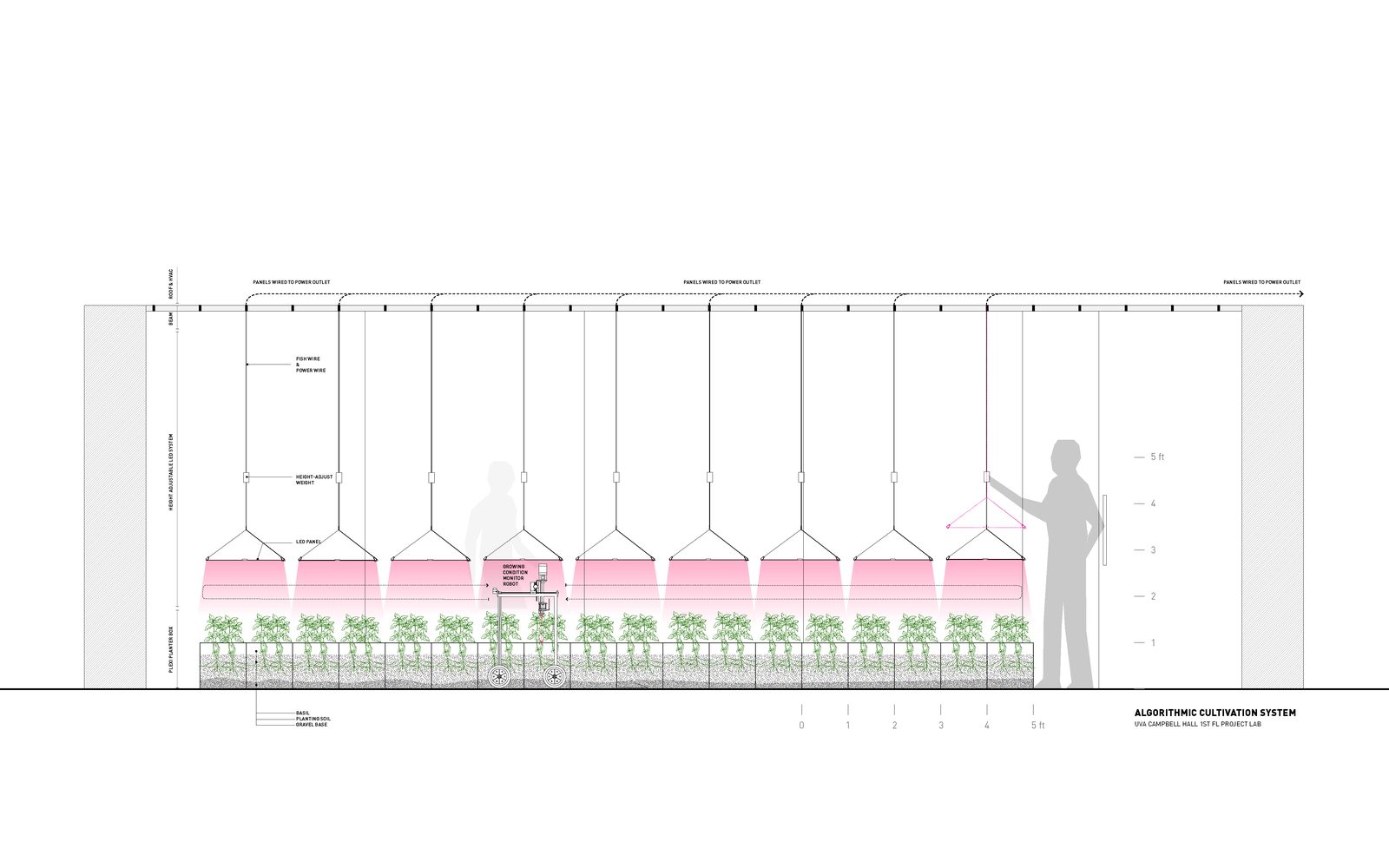
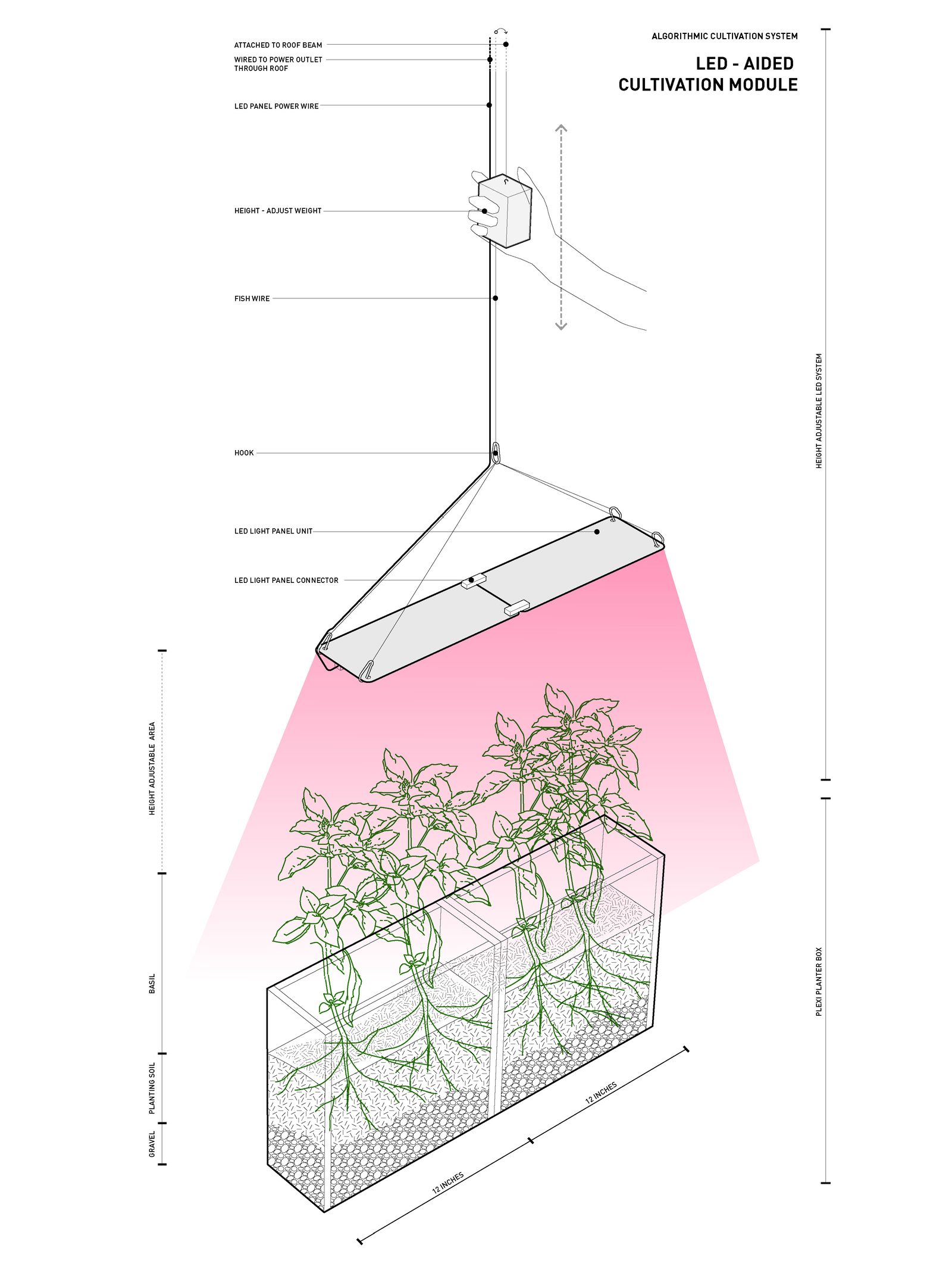
Figure 05_20Algorithmic Cultivation Section Layout | Bradley Cantrell, Robin Dripps, Lucia Phinney, Emma MendelFigure 05_21Algorithmic Cultivation Lighting Diagram | Bradley Cantrell, Robin Dripps, Lucia Phinney, Emma Mendel
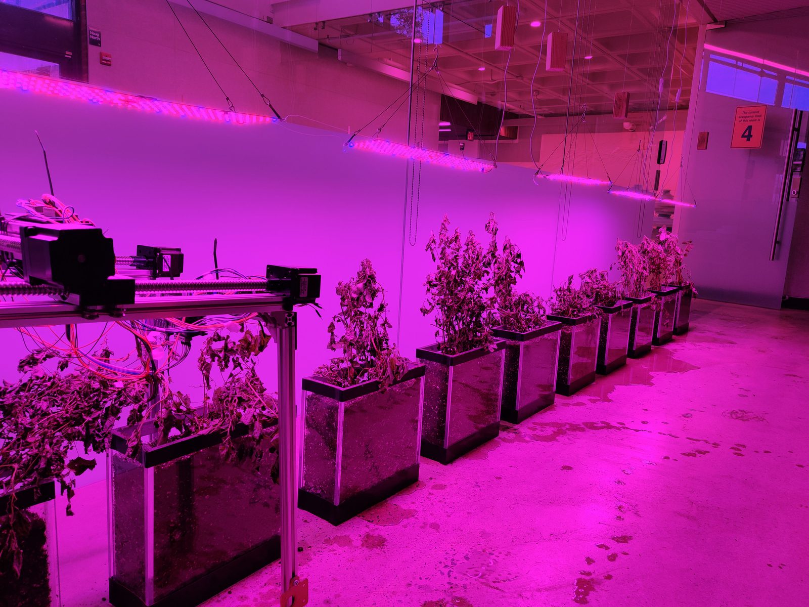
The work at UVA (2017–present), developed with Brian Davis and Xun
Liu, evolved the REAL methodology from focused research instrument into
a multi-purpose platform supporting PhD investigations, advanced
studios, and foundational instruction. The methods developed
experimentally at Harvard were codified, transforming experimental
practice into teachable methodology. The expanded sensing infrastructure
and programmable hydrographs enabled systematic experimentation while
acknowledging the inherent variability of complex systems. Tool
development is not a linear process of improvement. It is what Andrew
Pickering calls “the mangle of practice,” a dance of resistance and
adaptation where the tool pushes back against our intentions, revealing
new possibilities we didn’t anticipate (Pickering 1995). Tool
development requires accepting that materials, sensors, and systems have
their own agency and resistance.
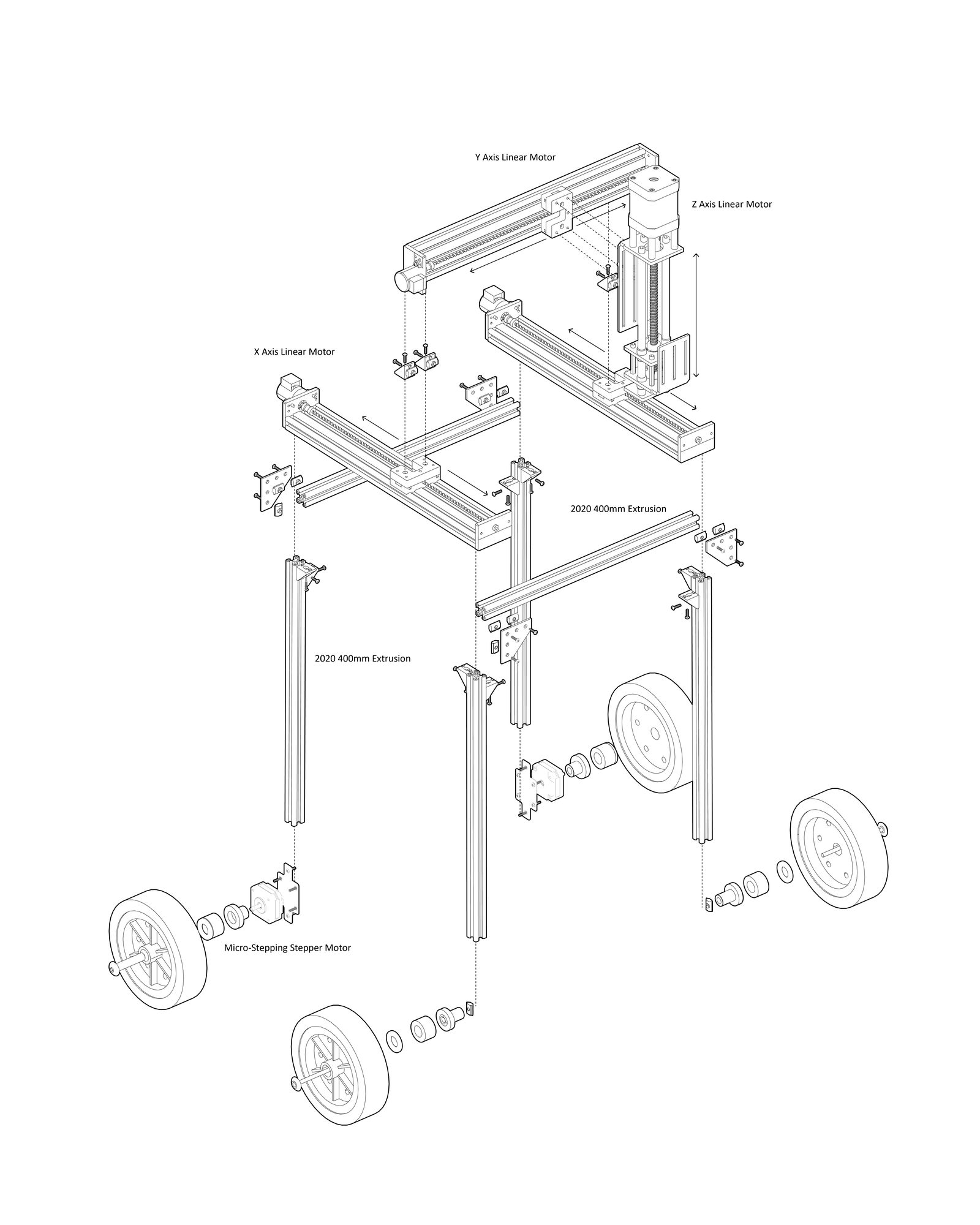
Figure 05_22Algorithmic Cultivation Robot Parts Iso | Bradley Cantrell, Robin Dripps, Lucia Phinney, Emma MendelFigure 05_23Algorithmic Cultivation Installation | Bradley Cantrell, Robin Dripps, Lucia Phinney, Emma MendelFigure 05_24Algorithmic Cultivation Installation | Bradley Cantrell, Robin Dripps, Lucia Phinney, Emma Mendel
“We shape our tools and thereafter our tools shape us.”
Marshall McLuhan (via J. M. Culkin, Saturday Review, March 18, 1967)
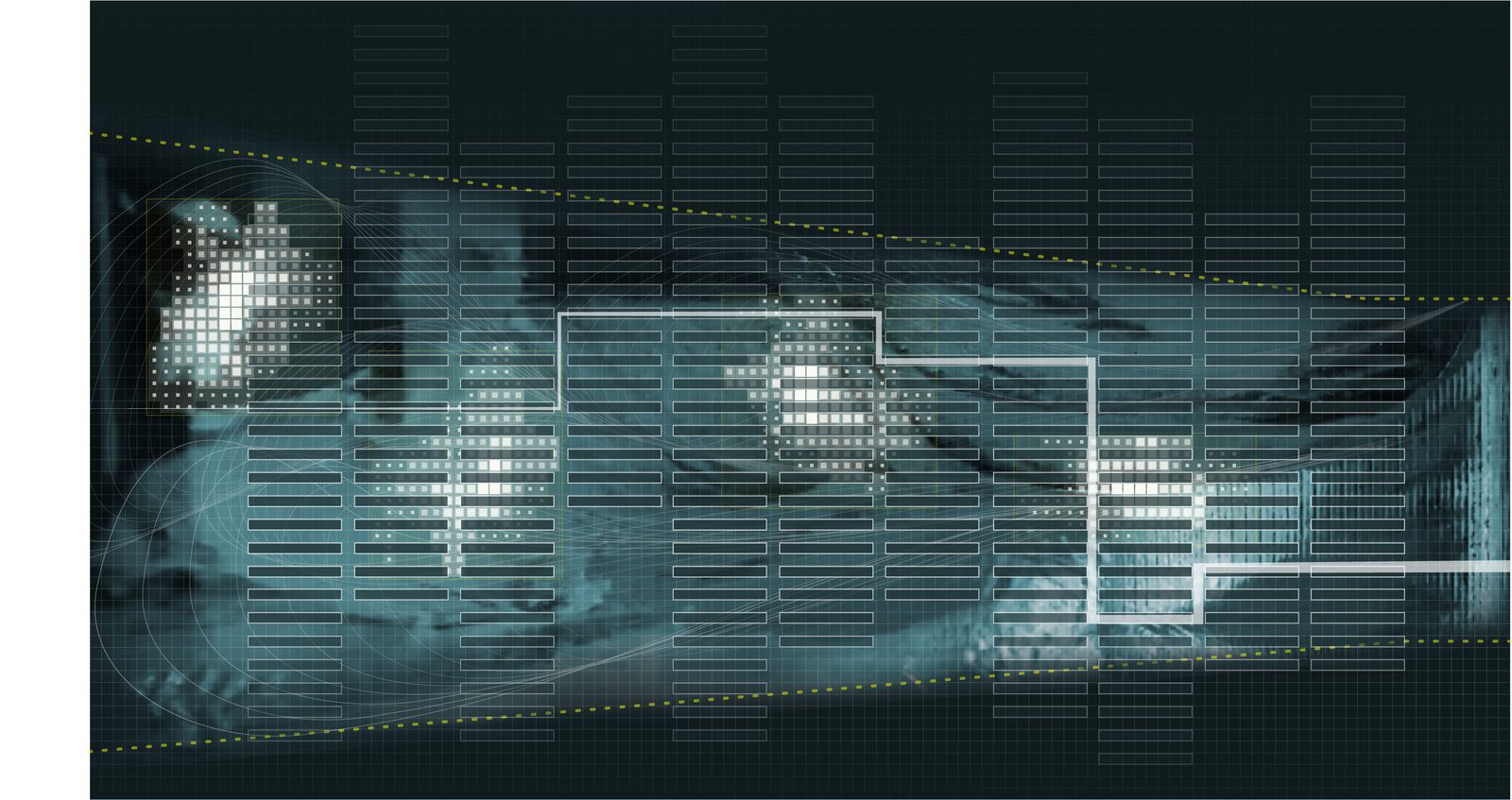
Figure 05_25
Mississippi River Delta Scale Visualization | Bradley Cantrell, Matthew Seibert, Ian Miller, Sylvia Cox
“Specific ways of measuring the world and specific categories for describing the world appear as common sense within this context while others become impossible — it is not that they are overtly censored, they aren’t even considered plausible.”
Robert Gerard Pietrusko, “A Speculative Cartography” (2020), pp. 125–126
Figure 05_26
Mississippi River River Scale Visualization | Bradley Cantrell, Matthew Seibert, Ian Miller, Sylvia Cox
“The individual technical object is an invented object, that is to say, produced by a game of recurrent causality between life and the thought of man.”
Gilbert Simondon, On the Mode of Existence of Technical Objects (1958; trans. Malaspina and Rogove, 2017)
Figure 05_27
Mississippi River Diversion Scale Visualization | Bradley Cantrell, Matthew Seibert, Ian Miller, Sylvia Cox
As institutional infrastructure, the UVA lab served pedagogical and
research missions. Refracted, its critical advance was the integration
of machine learning into the responsive framework enabling the
transition from responsivity to autonomy. Early thermostats operated
through fixed thresholds but contemporary systems like Nest develop
patterns through machine learning, optimizing across multiple variables.
The geomorphology lab became a testing ground for this transition
applied to landscape infrastructure, sediment gates that develop
response patterns through learned optimization rather than
pre-programmed rules. The gradient from interaction through responsivity
to autonomy maps a trajectory of increasing machine agency, one the lab
enables investigating at experimental scale before territorial
deployment.
The lab also produced new forms of landscape notation,
representations that speak to movement and probabilities of change
rather than capturing terrain as snapshot. Areas of stability and active
change appear as gradients rather than boundaries, providing graphic
language for landscapes understood as dynamic systems. The notation is
not neutral. The categories it makes visible are calibrated to the
practice’s own questions (Pietrusko 2020), and designing the notation is
itself a form of landscape design.
Codify (2018), co-edited with Adam Mekies, articulated the
conceptual shift from using computation for landscape architecture to
thinking computationally about landscape architecture. As an edited
volume, it surveyed the field, a professional resource collecting
diverse computational approaches. Refracted, its central argument was
the tool-maker turn, landscape architects must open the black box of
commercial software and write algorithms calibrated to specific
ecological questions. If ecological systems are too complex to fully
specify, and environmental conditions too variable to predict, then
design must operate through establishing rules and parameters within
which outcomes emerge. The designer’s role shifts from determining form
to calibrating process, a move from author to curator of algorithms.
Richard Hindle observed that the book “convincingly argues that
Landscape Architecture is uniquely positioned to define this sector of
technology, and in the process redefine itself.”
Then came the project that changed the trajectory. Algorithmic
Cultivation (2019), developed with Lucia Phinney, Robin Dripps, and
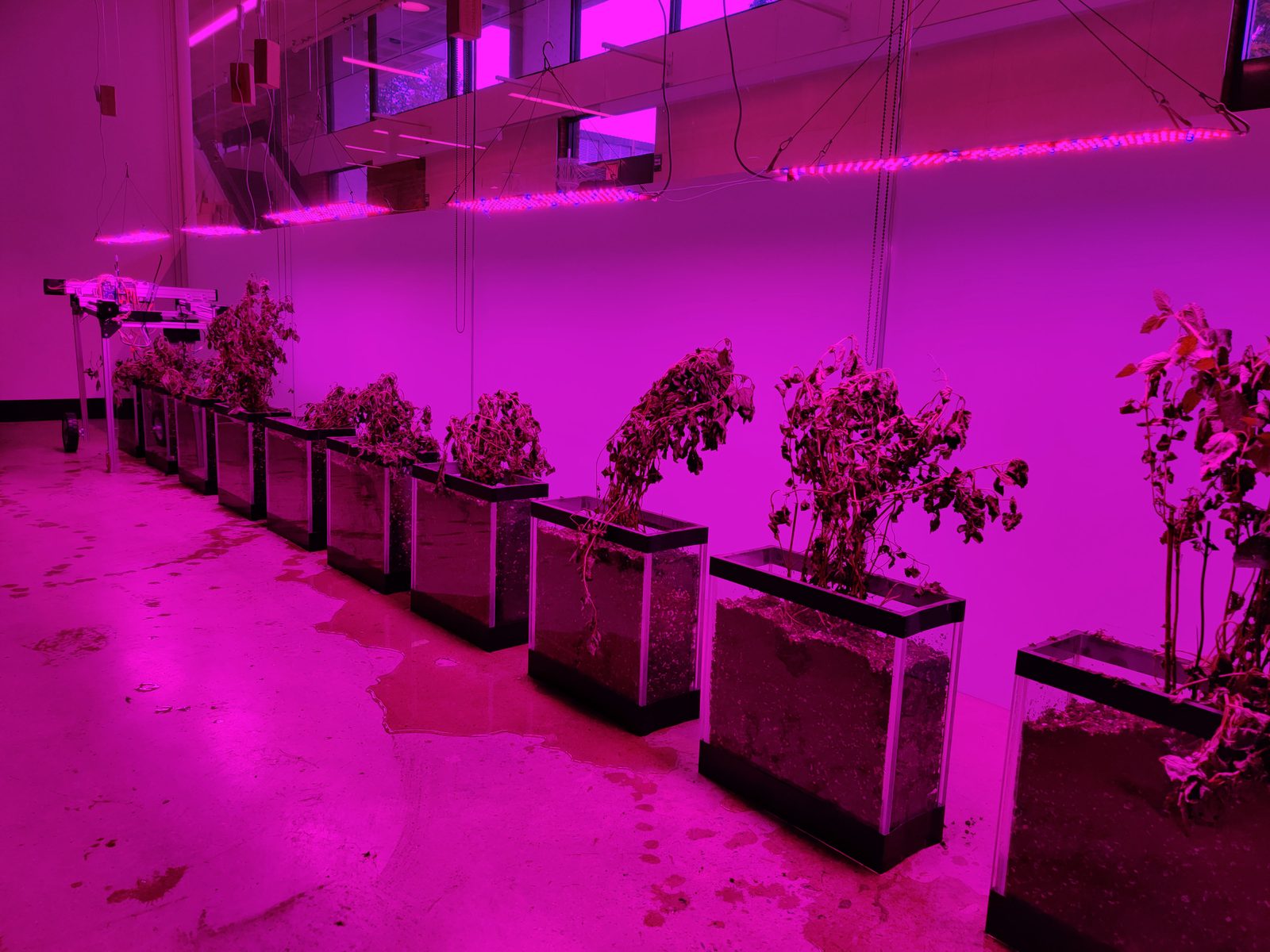
Emma Mendel at UVA, was an installation where a gantry robot pruned
living plants according to data streams external to the growing
environment, environmental data, species migration patterns, information
having no direct relationship to the plants themselves. The robot’s cuts
posed questions, the plants’ responses, measured through leaf size,
branching patterns, and color changes, provided responses. The data
became a medium for interaction rather than a tool for control.
The project was only partially realized. Technical difficulties
limited operation to a short period rather than the planned year-long
duration. As an art-science installation, it explored interspecies
communication and robotic cultivation. But this project’s refraction is
the most consequential in the dissertation. The failure was more
instructive than success would have been. The aspiration to maintain a
year-long feedback loop proved beyond the available technical and
institutional capacity, illuminating the gap between speculative design
and realized infrastructure that territorial-scale autonomous systems
would face at far greater magnitude.
I interpret the brief operation of the installation as a
specification of what an autonomous feedback loop requires. The
territory showed that sustaining such a loop demands not only hardware
but institutional infrastructure. Maintenance protocols, calibration
schedules, resource commitments. The gap between the proposition and the
institutional capacity is knowledge about the full scope of the system.
And the plant, meanwhile, responded to pruning according to its own
biological logic regardless of the data driving the robot. It grew where
it needed to grow. It was, in the most literal sense, smarter than the
model.
This was the moment the cultivant began to emerge though I would not
find a name for it until later. The plant in Algorithmic
Cultivation was not a passive recipient of robotic intervention but
an active participant whose responses could not be fully predicted or
controlled. The installation staged an encounter between human intention
(setting parameters), machine cognition (translating data into
movement), and biological agency (the plant’s own logic). Machine
cognition here operated as what this dissertation calls the Third
Intelligence, computational processing that is neither human judgment
nor biological response but a distinct mode of knowing that emerges from
algorithmic engagement with environmental data. The three intelligences,
human, biological, and computational, operated simultaneously, and the
knowledge the installation produced belonged to their interaction, not
to any one alone. Julian Raxworthy’s concept of the viridic, biological
autonomy, maintenance as design medium, gave me the theoretical frame.
The cultivant, my extension of Raxworthy, would name the relationship
that emerges when design deliberately engages that autonomy as a
co-author rather than a substrate. None of this was visible in the
installation’s original framing. It required refraction, the doctoral
re-reading, to see what the plant had been telling me.
Failure (2019–2020), a drawing and film developed with Emma
Mendel for exhibitions at Pratt Institute and the Chicago Architecture
Biennial, made the epistemological argument explicit. The drawing
accumulated through months of iterative process, code-generated base,
ink, chemical transfers, erasure and with each layer responding to
traces of previous layers while establishing conditions for subsequent
interventions. No layer was treated as sacred. Errors were not
eliminated but incorporated. The companion film catalogued two centuries
of environmental failures, presenting failure not as aberration but as
constituent element of environmental history. Exhibited as artistic
practice, the drawing and film were received as meditations on
complexity and indeterminacy. Refracted, they articulated the paradigm
shift at the heart of this dissertation, from predict-and-control to
learn-and-adjust. The ecological science here is unambiguous. Hastings
and Wysham (2010) demonstrated mathematically that regime shifts in
complex ecological systems can occur with no warning, that in systems
exhibiting nonlinear dynamics and multiple attractors, the variance and
skew that theoretically precede a shift simply do not appear. “Drastic
changes can appear in nature without warning.” Landscapes fail not
because designers err but because complex systems exceed the predictive
capacity of any model built to describe them. The design question is not
how to prevent failure but, drawing on Nassim Taleb’s concept of
anti-fragility, how to develop systems that more readily recover from
disturbance and grow stronger through encounters with the
unexpected.
By the end of this phase, I had learned to write my own tools, and
one of them, the robot gardener, had shown me something I did not
expect. I learned that the plant has its own intelligence, and the
design must make room for autonomy.
Learning to Let Go (2017–2025)
The emergence of machine learning and artificial intelligence as
practical design tools prompted a fundamental reconsideration of agency.
Previous phases had developed responsive systems, environments that
reacted according to pre-specified rules. But AI systems learn, adapt,
and generate behaviors not explicitly programmed. They introduce a mode
of autonomy that challenges traditional assumptions about the designer’s
role. The projects of this phase ask how landscape architecture might
collaborate with, rather than merely deploy, artificial intelligence and
what it means to design systems that eventually exceed the designer’s
comprehension.
Designing Autonomy (2017), co-authored with Laura J. Martin
and Erle C. Ellis and published in Trends in Ecology & Evolution,
articulated the paradox directly, that maintaining wild places in the
Anthropocene increasingly requires intensive human intervention. The
paper proposed that this paradox might be resolved through fully
automated systems capable of creating and sustaining wildness without
ongoing direct human involvement. Published in a leading ecology
journal, the paper was framed as a contribution to conservation science,
bringing landscape architecture’s engagement with responsive
technologies into dialogue with rewilding discourse and AI research.
Refracted, it introduced two concepts that anchor the dissertation’s
theoretical framework in the wildness creator, an autonomous landscape
infrastructure whose operations would eventually become “unrecognizable
and incomprehensible to human beings” and distanced authorship, the
practice of designing systems that operate beyond the designer’s direct
control. The concept inverted Leo Marx’s “machine in the garden” into
the machine as gardener. To design spaces free from human influence
requires stepping back from conventional design control speculating on
the ultimate expression of learning to let go.
The paper introduced a two-axis diagram mapping ecosystems by
relative human and nonhuman influence, revealing that both can increase
simultaneously through “intensive rewilding.” Drawing on Parasuraman et
al.’s taxonomy of automation, it distinguished levels of automated
environmental management, from information acquisition through action
implementation, and explored what happens when deep reinforcement
learning systems learn conservation strategies through environmental
interaction rather than following pre-programmed rules.
“Tools that serve conviviality allow their user to exercise their human autonomy and creativity.”
Ivan Illich, Tools for Conviviality (1973)
Figure 05_46
Fort Proctor Site Inventory | Bradley Cantrell, Ursula Emery McClure + photo by Bogdan Oporowski
Figure 05_47Failure, layered drawing for Drawing Codes Exhibition and Book | Bradley Cantrell, Emma MendelFigure 05_48Failure, animation for Storm Signals Event, Chicago Illinois | Bradley Cantrell, Emma Mendel
Indeterminate Futures (2021), developed with Xun Liu for the
Venice Architecture Biennale, addressed the problem of documenting
systems that never repeat. Years of geomorphology table imagery were
minted as NFTs on the Tezos blockchain, each 15–30 second increment a
unique digital object, the archive growing throughout the Biennale as
new experiments were conducted. As a Biennale digital exhibition, the
project engaged contemporary discourse around NFTs, documentation, and
distributed archives. Refracted, it resolved a representational problem
that had persisted since Phase I. How to document processes whose
essence is transformation. Instead of seeking a definitive image, the
project produced an expanding archive of singular moments, each unique
yet connected through underlying process. Representation became
accumulative rather than definitive, a notation system adequate to
landscapes understood as fundamentally indeterminate.
Prototyping the Bay (2025), co-taught with Leena Cho at UVA
and recipient of the Tulane Climate Curriculum Prize, translated the
full theoretical arc into pedagogy, and in doing so, tested whether the
frameworks were transmissible or merely personal. The studio positions
the Chesapeake Bay as both subject and instrument, a territorial
landscape engaged as adaptive infrastructure responding to
environmental, programmatic, and sociocultural flux. Students confront
the challenge of designing for landscapes that never look the same,
developing propositions for futures that are, at best,
unpredictable.
The studio’s central provocation distinguishes between territory (“an
abstracted space composed of objects and processes for the purposes of
state administration, state borders, census tracts, tax parcels”) and
landscape (“the living medium, always evolving... composed and
choreographed to produce life catalyzing forms”). This distinction
frames landscape architecture’s unique capacity to engage territorial
systems through living processes rather than administrative abstraction.
The site, the coastal landscapes and islands of Pocomoke Sound, where
sea-level rise, land subsidence, and shifting ecological communities
create conditions of radical uncertainty, was chosen precisely because
it resists the predict-and-control paradigm. Within this marginalized
environment, the studio identifies “a latent wildness, remote areas that
are difficult to access, novel ecological systems, hyper productive
logistics, sites of extraction, cultural enclaves, and powerful
infrastructures.”
The pedagogical structure operates through three modules that model
adaptive epistemology at the scale of a semester. Module I (Unpacking
the Bay) combines research, mapping, modeling, and manifesto creation,
students develop familiarity through multiple representations and scales
while establishing core design values. Module II (Systems, Models,
Surrogates) tests those values through systems diagrams and site
prototypes, employing geomorphology table techniques, generative AI
tools, and machine learning applications in rapid iterative cycles.
Module III (Landscape as Experiment) develops comprehensive design
strategies treating the Chesapeake as dynamic landscape shaped by
multiple agents, “human/non-human, geologic, historic, biologic,
political, hydrological,” confronting the tension between
experimentation and conservation.
As a teaching studio, the course fulfilled a curricular requirement.
Refracted, it performed the dissertation’s central argument in that
sites function simultaneously as models and cultural artifacts requiring
design proposals to ask questions and for landscapes to produce
knowledge through their own transformation. The studio draws explicitly
on the “Wild Disequilibria” framework, “Classical wilderness is
characterized by purity, it is unsettled, uncultivated, and untouched.
But given the massive reshaping of ecological patterns and processes
across the Earth, wilderness has become less useful, conceptually.
Wildness, on the other hand, is undomesticated rather than untouched.”
The shift moves design priorities from maintaining purity to creating
plural conditions of autonomy and distributed control. Students must
develop coherent design values that speak to their convictions, the
ethical positioning this dissertation argues is inseparable from
technical capability. The Tulane Climate Curriculum Prize confirmed that
the frameworks transmit, what began as one practitioner’s adaptive
methodology could structure another generation’s design thinking.
The consultation for NEOM (2022–2025), developed with Adam Mekies
through Sherwood Design Engineers, tested these frameworks at
territorial scale. The project developed ecological strategies for the
landscapes surrounding The Line, a 170-kilometer linear development
traversing desert terrain from mountains to coast. The central design
proposition positioned The Line as a landscape manifold, an
infrastructural form that concentrates and redistributes water
resources, channeling flow to catalyze new habitats, vegetated regions,
and carved geologies.
North of The Line, water is routed to erode and carve the ground
intentionally, creating ravines that shelter life, areas selectively
ossified while others erode, producing differentiated terrain through
controlled hydrological action. The wadis are reconceived as holding
areas, water pushed back into them to irrigate and recharge aquifers.
South, a managed water system creates landscapes that nourish and
cleanse themselves, detention areas of salt brine forming geometric
colored mirrors, a fluctuating isohaline regulated through water inputs,
thriving mangroves stitching together the coastline. Adaptive canopy
structures fabricated from mineralized sequestered carbon build
themselves, responding to the life that forms below.
Hydrological modeling using GeoHECRAS revealed that conventional
approaches, channelizing flood waters would require widths exceeding 200
meters of hardened concrete infrastructure. This finding drove the
development of more nuanced approaches, a hybrid hydrological management
that engages the complex interactions supporting ecosystem health rather
than minimizing indeterminacy through simplified infrastructure. The
project envisioned an internet of ecologies, an interconnected network
of biodiversity hotspots, ecological corridors, and migration routes
relaying real-time data through local sensors and remote monitoring
systems.
As a territorial consultation, NEOM was a client deliverable with
design proposals, narrative development, and technical modeling for a
sovereign mega-project. This project’s refraction is perhaps the most
uncomfortable and the most necessary. Refracted through the ethical
frameworks that Branding Islands first exposed, NEOM became the
forcing function for the dissertation’s justice arguments. The adaptive
frameworks developed through twenty years of practice met the reality of
sovereign power, resource allocation, and ecological protection. The
tension between technical capability and ethical responsibility and
between what responsive systems can do and what they should do is
unresolved. It is, I believe, unresolvable in advance. It can only be
navigated through the kind of provisional, reflexive, adaptive practice
this dissertation describes.
Theory Distilled from
Practice
Twenty years of projects, and I return to where I started, the
practice as experiment. Each phase revised the hypothesis of the last. I
learned to see dynamic systems, then to touch them, then to code them,
then to let them go. The theory proposed in this dissertation, adaptive
epistemology, the cultivant, Reflexive Stewardship did not emerge from
abstract reasoning. It was distilled from the friction of making, and it
became visible only through the deliberate refractions of doctoral
inquiry.
No single project contains the theory. The Sedimachine does
not contain adaptive epistemology, REAL does not contain the cultivant,
NEOM does not contain Reflexive Stewardship. Each project, in its
instrumental life, answered the question it was asked to answer and
answered it clearly. But the questions this dissertation asks were never
posed in those contexts. It was only by re-reading the work from vantage
points that grants and competitions and consultancies never demanded
that the deeper contributions became legible and a practice that had
been producing epistemological evidence all along, without yet having
the framework to name it. The framework emerged from the refractions
themselves, from the sustained act of looking at the same body of work
and finding, each time, something that had been present but
invisible.
Refraction as method has limits, and naming them is part of the
claim. The method works here because the projects are real in that they
are realized, documented, peer-reviewed, exhibited, or built. A
speculative portfolio that existed only as proposals could not sustain
this kind of re-reading, there would be nothing for the new angle of
inquiry to catch against. The method also works because the PRS
structure provided external accountability with colleagues and critics
who could see what the refractions revealed and press back where they
overreached. Kelsch’s insistence on geographic specificity was precisely
this kind of check, as a reminder that the model’s behavior was
conditioned by particular sediment loads and flow regimes, not freely
generalizable. Refraction does not replace conventional empirical
research or site-specific analysis, it complements them by surfacing the
epistemological dimensions that instrumental contexts suppress. The
claim is not that any practice can be refracted into theory. The claim
is that sustained, realized, iteratively examined practice produces
knowledge that becomes legible only through deliberate re-reading and
that this dissertation demonstrates one disciplined way of conducting
that re-reading.
The adaptive epistemology proposed here was not designed. It was
cultivated.
The practice has now been laid bare. But each project in that
catalog involved a model… a physical table, a simulation, a scaled
environment. What is a model? What is it for, epistemologically? The
tradition of fluvial modeling that these projects inherit was built on
prediction and stability. At what point, and how, does the model become
something else, an instrument of discovery rather than a tool that
forecloses futures?